

Hurricane Sandy Path 2012: Live Tracker And City-By-City Guide Of Peaks, Impact Times

On Monday, Hurricane Sandy made its way towards the East Coast, slated to made a landfall somewhere between New Jersey and Maryland late Monday night, but not before barreling through major cities from New York to Boston to Washington to Baltimore.
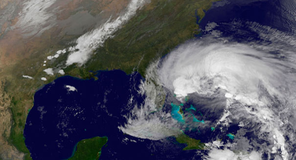
Weather forecasters called Hurricane Sandy a rare "super storm" classified as category one with winds up to 85 miles per hour all the way up to New England.
Sandy was caused by an Arctic jet stream wrapped around a tropical storm and could cause up to 12 inches of rain in some place and two feet of snow in the Appalachian Mountains from West Virginia to Kentucky. Many cities will also face widespread power outages, which prompted the closures of some transit systems Monday as well as school closures and halted flights.
According to The National Weather Service, Sandy was about 310 miles south-southeast of New York City moving north-northwest at about 20 miles an hour around 8 a.m. EST.
US President Barack Obama called the storm "serious and big," prompting the cancellation of his campaign tour in Florida. The New York Stock Exchange also closed for the first time since 1985 and more than 8,000 flights were cancelled between major cities in the U.S.
While Sandy is set to be the biggest storm to threaten the East Coast in years with its damaging winds and slow moving rainfall, each city has its own peak for the storm and specific impact times.
Below is a city-by-city guide of peaks and impact times, courtesy of the Weather.com live tracker for Hurricane Sandy.
Washington D.C.
List of closures, courtesy of the Washington Post.
Warning updates and peak times, courtesy of Weather.gov.
Forecast: Widespread tree damages and power failures in residential areas from high winds expected. Low-lying city areas like Georgetown and tidal basin of Potomac River expected to flood.
Philadelphia, P.A.
List of closures, courtesy of ABC.
Warning updates and peak times, courtesy of Weather.gov.
Forecast: With Philadephia in the center of Hurricane Sandy, over a foot of rain and heavy winds are expected to pass over Philly Sunday night into Monday night. The storm's peak late Monday will bring winds exceeding 60 miles per hour, the National Weather Service said.
Newark, N.J.
List of closures, courtesy of NJ.com.
Warning updates and peak times, courtesy of Weather.gov.
Forecast: New Jersey will face winds exceeding 75 miles per hour. Gov. Chris Christie said the center of the storm and landfall could be somewhere between Toms River and Atlantic City, but areas hundreds of miles outside the center will be impacted.
New York, N.Y.
List of closures and evacuation zones, courtesy of The New York Times.
Warning updates and peak times, courtesy of Weather.gov.
Hardford, C.T.
List of closures, courtesy of WTNH News 8.
Warning updates and peak times, courtesy of Weather.gov.
Forecast: Mass flooding is expected in Connecticut. Old Saybrook to Fairfield homes in low-lying areas were evacuated due to flooding concerns on Sunday. The Long Island Sound could face the worst flooding.
Newport, R.I.
List of closures, courtesy of Patch.
Warning updates and peak times, courtesy of Weather.gov.
Forecast: High winds and heavy flooding are expected with high tides on Monday, around 8 a.m. and again around 8 p.m. which will cause massive floods. Evacuations were issued in Misquamicut south of Shore Road, low-lying areas of Weekapaug, Watch Hill and Avondale and areas along the Pawcatuck River up to the Stillman Avenue Bridge.
Boston, M.A.
List of closures, courtesy of BostInno.http://bostinno.com/2012/10/28/what-is-closed-boston-hurricane-sandy/
Warning updates and peak times, courtesy of Weather.gov.
Forecast: Beginning 6 a.m. EST on Monday, Massachusetts is expected to have coastal floods and high winds.
© Copyright IBTimes 2025. All rights reserved.
- MOST POPULAR IN Science


