

ISS Astronaut Snaps Photo Of Shelter Cove On California's 'Lost Coast'

KEY POINTS
- An astronaut aboard the ISS captured an image of Shelter Cove on California's Lost Coast
- The image captured the small roads, black beaches and airport strip in the area
- The area is known as Lost Coast because it is rather isolated
- Photos of Earth from space provide insight on the changes happening on the planet
An astronaut aboard the International Space Station (ISS) snapped a photo of Shelter Cove along California's so-called Lost Coast. Such images of Earth from space are of great value to scientists and the public.
Lost Coast From Space
Last Dec. 28, a member of the Expedition 61 crew snapped a photo of Shelter Cove using a Nikon D5 digital camera while the ISS was flying over the Pacific Ocean.
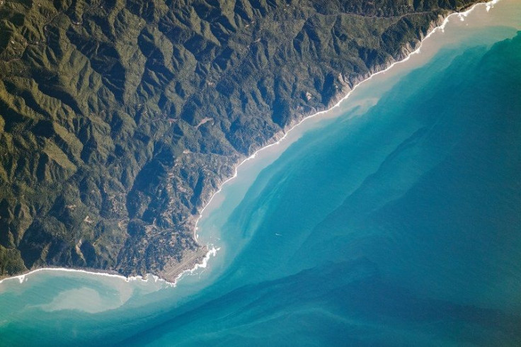
A close look at the image shows light-toned lines of the roadways, while the most prominent feature of the town, the airstrip of Shelter Cove Airport, can also be seen. Black sand beaches that get their color from altered sedimentary and igneous rocks are also visible north of Shelter Cove or along the left side of the coast in the photo.
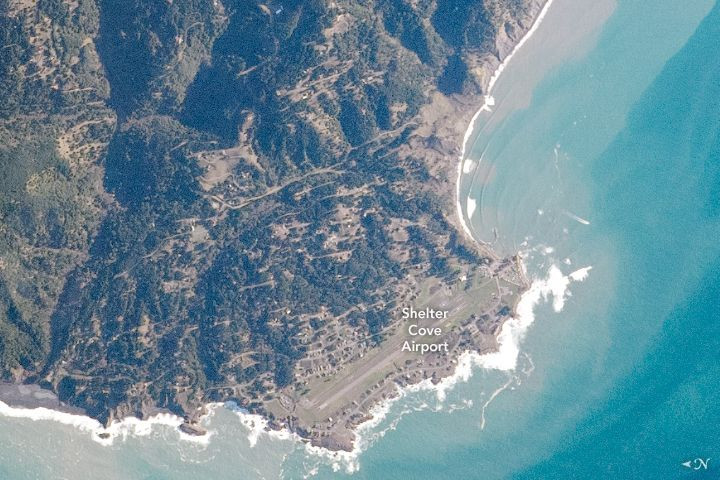
The photographs of the small hamlet have been cropped and enhanced for improvement and lens artifacts have been removed.
Lost Coast
The reason why much of the region has been dubbed as California’s Lost Coast is that building a highway on its steep, rugged terrain was deemed to be too difficult and costly. As a result, the highway does not reach the coastal communities, leaving them rather isolated and reachable only by air, sea or narrow roads.
The region is home to King Range Conservation Area, which was the first national conservation area in the United States. Today, people can visit King’s Range Wilderness but anyone who wishes to go camping overnight will have to acquire a permit.
Astronaut Photography
Since the space missions in the 1960s, astronauts have been taking images of the Earth from space, capturing images of events such as volcanic eruptions, floods, and storms. These photographs are not just pretty but, they also help look after the health of the planet and the creatures in it.
By looking at the photos from space, scientists are able to document major Earth events and monitor the environmental impacts of human activity such as city growth, extensive use of artificial lights and agricultural expansion.
Apart from providing scientific insight, photos of the Earth from space have been increasing environmental awareness as people get to see the Earth from a completely different point of view.
© Copyright IBTimes 2025. All rights reserved.
- MOST POPULAR IN Science


