

LOOK: Satellite Captures 'Ominous' Image Of Iceland Volcanic Eruption

KEY POINTS
- A volcano on Iceland's Reykjanes peninsula erupted last week after over 800 years
- An "ominous" satellite image shows glowing clouds over the eruption
- Another image shows the region before and after the event
Lava began bursting out of a crack near Iceland's Mount Fagradalsfjall last week after over 800 years of dormancy. NASA satellites have captured incredible views of the event.
The volcanic eruption in the Reykjanes peninsula began on March 19. Although the area was initially closed off due to the possible dangers, people were allowed to trek to the location by Saturday afternoon and witness the stunning event.
A video shared on Twitter shows incredible views of the eruption and the slow-moving hot lava.
Seems like my video went full throttle! More on my YouTube channel pic.twitter.com/RzrRniXxPu
— Bjorn Steinbekk (@BSteinbekk) March 22, 2021
Another video showed scientists grilling hotdogs on the lava while they were studying the eruption.
NASA and the United States Geological Service's (USGS) Landsat 8 satellite also captured a rather unique view of the eruption from its orbit. The image, which was captured three days after the eruption began, doesn't show the eruption itself but actually highlights the thick clouds over the eruption site appearing to "glow."
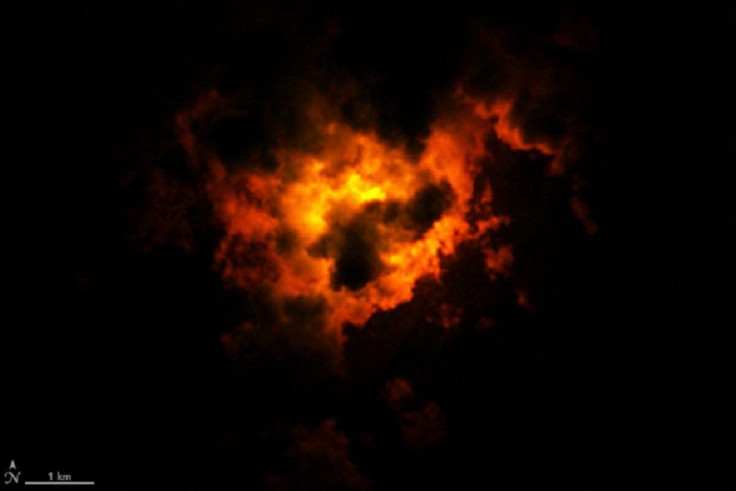
It is a false-color image made by combining the shortwave and near-infrared data, NASA Earth Observatory said. The clouds appear to be glowing because "extremely hot" features, such as the lava below, can "glow" in the shortwave-infrared part of the spectrum.
"While nighttime images like this one might appear ominous, the Icelandic Met Office notes that dangers from this eruption are currently limited to the vicinity of the eruption site and nearby valleys," NASA Earth Observatory explained.
Another nighttime satellite image, taken by NASA and the NOAA's Suomi NPP satellite, compared a night view of western Iceland just days apart.
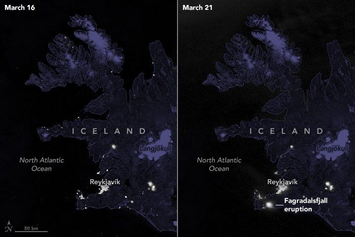
The image on the left shows the area on March 16, days before the eruption, while the one on the right captured the same area on March 21, after the eruption. In the second image, one can see a large and bright patch of light coming from the Reykjanes peninsula where the eruption occurred.
"While small in comparison to other recent eruptions in Iceland, the event was bright and large enough for NASA and NOAA satellites to observe," according to the NASA Earth Observatory.
Minor eruption
Although the eruption is quite historic since it happened after over 800 years of dormancy, the Iceland Meteorological Office (IMO) considers it a "minor eruption."
It also warned of "unhealthy air quality" close to the eruption site in its recent update.
Decreas. SW-ly wind today, unhealthy air quality exp. near the eruption site after 19:00 today. SO2 concentr. close to the volcano can go over 9000 µg/m3, and gather in valleys/dells in the landscape. It is advised to leave the area before 17:00 and keep away from valleys/dells pic.twitter.com/dvm98DqR2i
— Icelandic Meteorological Office - IMO (@Vedurstofan) March 23, 2021
© Copyright IBTimes 2025. All rights reserved.
- MOST POPULAR IN Science


