MH370 Cockpit Seen In New Google Maps Cambodia Images, Theorist Claims
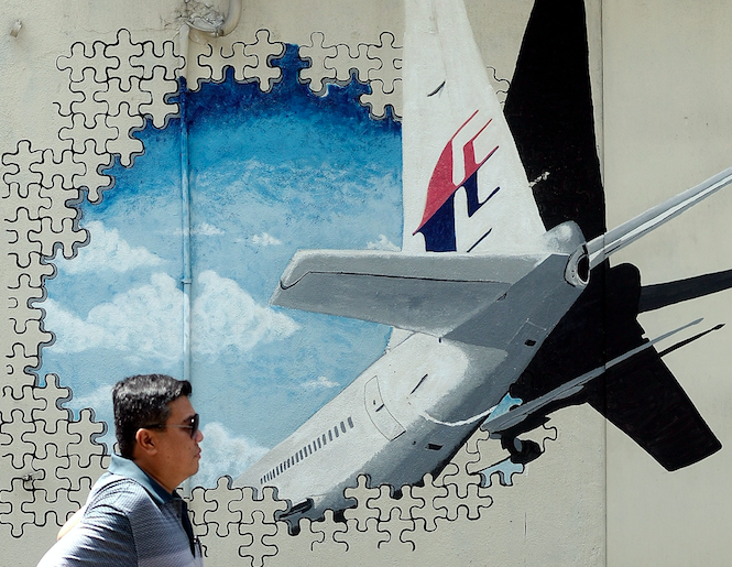
Images from Google Maps of an area northwest of Cambodia’s capital Phnom Penh shows the nose of missing Malaysia Airlines Flight MH370, aspiring pilot Daniel Boyer claimed. The hunt for the Boeing 777-200 intensified a month ago when video producer Ian Wilson claimed the missing plane was most likely in the Cambodian jungle.
This month, Wilson planned for a ground search of the jungle to prove his claim about the location of Flight MH370. New Google Maps photos of the Cambodian region shows several white objects -- one piece measures 17.8 feet, which is close to the nearly 19 feet of a Boeing 777 cockpit, the Daily Star reported. However, these claims cannot be verified independently since no such objects could be seen on the maps at the time of publishing this story.
“I am convinced this shows the cockpit," Boyer told the British tabloid. “It has to be investigated as soon as possible to help solve the mystery.”
The latest claim adds weight to Wilson's assertion that flight MH370, which went missing March 8, 2014, went down in the Cambodian jungle. The plane was traveling from Kuala Lumpur to Beijing when it went off radar with 239 people on board.
In July, Malaysia released a full report detailing the investigation into the plane's disappearance. Investigators wrote in the report they were unable to determine what happened to the Malaysia Airlines flight. However, families of those on board the jet claimed authorities were hiding the truth and the Malaysian government was involved in a massive cover-up.
Despite a multimillion-dollar search operation in a remote part of the southern Indian Ocean, authorities found no clue into the plane's disappearance. The biggest lead in the investigation came when a plane flaperon was found by villagers on Réunion Island. Investigators said in the report 27 pieces of wreckage were believed to be from MH370, though only three have been confirmed as parts belonging to that plane.
Recently, Google Maps updated its satellite images of the Cambodian region and it was alleged the new images continued to show the plane in the same location. According to theorists using Google Maps data, the plane has remained at the same location on satellite images dating from 2017 and 2015. This could likely debunk claims the satellite caught an in-flight plane when it took the pictures.
"If they cached the image since 2014, it is either the satellite they use never updated the datasets for four years, or there is a system glitch," aviation expert Yijun Yu told the Daily Star earlier this week, adding the time stamp doesn't prove anything.
Since the plane disappeared, conspiracy theories have emerged. Some claimed the pilot crashed the plane in a "death-dive," while others hinted at a possible hijack. An oceanographer who found Air France flight 447 claimed last week that the location where the missing plane went down must be known to the governments.
"How could an aircraft be in the air for seven hours without someone looking for it?" David Gallo told the Sun. "The issue there was that it wasn't clear we were getting the best information from Malaysia. That is one of the big issues... The primary radar data of what happened that night I don't believe that we actually saw. I think we saw the records."
"I don't think the U.S. would know, I just think any aircraft missing for that long, someone would look to see where it would be... There's plenty of satellites in that area, so my question is how could an aircraft be in the air for seven hours without someone looking for it?" he added.
© Copyright IBTimes 2026. All rights reserved.
- MOST POPULAR IN World