

NASA Satellite Image Shows 'Rosette' Clouds Off Australian Coast

KEY POINTS
- A NASA satellite image shows cloud rosettes off the coast of Australia
- The unusual clouds are called actinoform clouds
- These clouds can only be seen from space because they are so massive
- The mechanisms that cause actinoform clouds to form are still not well understood
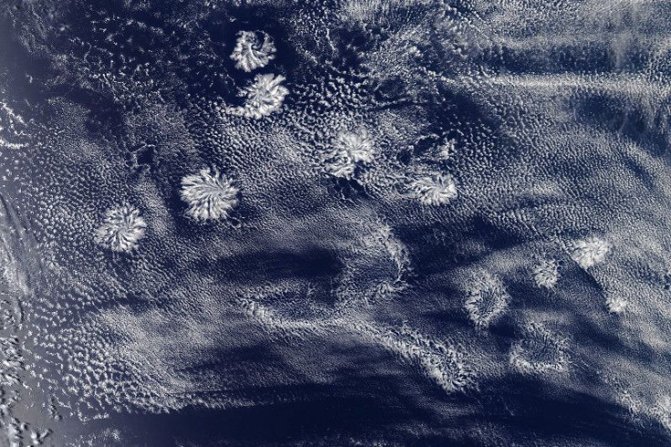
The Moderate Resolution Imaging Spectroradiometer instrument on NASA’s Aqua satellite captured an image of what looks like rosette-shaped clouds off the western coast of Australia. Although this class of clouds has been observed for decades, the mechanisms behind what causes them remain largely unknown.
Rosette Clouds
On Jan. 29, 2020, NASA’s Aqua satellites captured an image of clouds that look rather like pom poms or rosettes. According to NASA Earth Observatory, these clouds are called Actinoform clouds and they typically organize themselves in radial structures or sometimes even in lines.
These clouds, however, cannot be recognized from the ground because they are massive in size, often reaching 180 miles (300 kilometers) across low stratocumulus cloud fields over water.
Interestingly, the clouds in this image are quite unusual because they are not in a location where they usually form.
“This scene is interesting because it's a little to the north of the typical stratocumulus region to the west of Australia,” cloud researcher at NASA, Michael Garay, said.
Mysterious Clouds
Because they are so massive in size that they are impossible to recognize from the ground, the first time that actinoform clouds were detected and recorded was in Hawaii on Aug. 16, 1962, when the satellite era had already dawned.
Over the next five decades, satellite images revealed that actinoform clouds are actually more complex but more common than previously thought. In fact, they occur practically everywhere that stratocumulus clouds are also forming.
However, despite advances in satellite technology that have allowed for plentiful observations and incredible images of actinoform clouds, the mechanisms by which they form remain unknown. So far, researches have linked the formation of actinoform clouds to aerosols. However, that scenario is rather unlikely for Jan. 29 image because the clouds are too far from land for the effects of aerosols.
Interestingly, although the clouds look quite attractive from the satellite images, their effect on the ground is less so. Depending on the season, when actinoform clouds blow ashore, they can bring drizzle and gloomy weather along. In fact, in California, weather patterns associated with actinoform clouds have been given the nicknames “May Gray” and “June Gloom,” both pertaining to a chain of dreary, overcast days.
© Copyright IBTimes 2025. All rights reserved.
- MOST POPULAR IN Science


