

NASA Spots Stunning New Mars Impact Crater With ‘Standout’ Appearance [PHOTO]
NASA has captured a "fresh" impact crater on Mars in a stunning view of the Red Planet's surface.
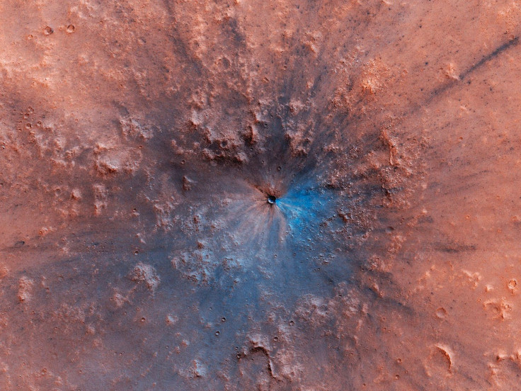
On April 17, NASA's Mars Reconnaissance Orbiter (MRO) took a color-enhanced image of the newly spotted crater using its High Resolution Imaging Science Experiment (HiRISE) camera which the mission team at the University of Arizona recently shared on Twitter. Described as a "work of art," this fresh crater apparently "stands out" due to the presence of the darker shades of Martian soil. The darker material beneath the reddish surface had been exposed after the impact kicked up the loose dirt on top.
According to the photo description on the HiRISE website, the Mars impact crater may have formed somewhere between September 2016 and February this year. The image, meanwhile, was taken on April 17 by the Mars Reconnaissance Orbiter's camera from an altitude of 158 miles (255 kilometers).
Meanwhile, the orbiter also recently spotted an unusual formation on Mars' surface. An image captured by the HiRISE camera on April 22 showed a series of strange chevron symbols that appear to resemble the iconic "Star Trek" Starfleet logo on a Martian sand dune in the southeast Hellas Planitia region.
"Enterprising viewers will make the discovery that these features look conspicuously like a famous logo," the MRO HiRISE team posted on Twitter last week.
Caption Spotlight (12 Jun 2019): Dune Footprints in Hellas
— HiRISE: Beautiful Mars (NASA) (@HiRISE) June 12, 2019
Enterprising viewers will make the discovery that these features look conspicuously like a famous logo.
More: https://t.co/CAq5xBbDwf
NASA/JPL/University of Arizona#Mars #science pic.twitter.com/N5MfKQPiYt
The Martian formations were apparently created by lava, wind and dunes. They were previously large, crescent-shaped dunes that were surrounded by lava after an eruption before solidifying. Wind blowing over the dunes eventually removed most of the sand, leaving behind what is called a dune cast. These "footprints" are evidence of dunes that were surrounded by lava.
The Mars Reconnaissance Orbiter has been observing and taking images of the Red Planet for over a decade, after launching from Cape Canaveral in 2005. Its main goal had been to find proof that water once flowed through the Martian surface and how it all disappeared.
The MRO has captured thousands of images over the years, many of which show the remains of what are believed to be rivers and lakes. One recent photo taken by the MRO HiRISE shows gullies on the outer crater wall in Nereidum Montes, a mountain range on Mars that stretches 710 miles (1,143 kilometers).
Hi3D (13 Jun 2019): Gullies on the Outer Crater Wall in Nereidum Montes https://t.co/XxKg1RDnRR
— HiRISE: Beautiful Mars (NASA) (@HiRISE) June 13, 2019
NASA/JPL/University of Arizona #Mars #science pic.twitter.com/lsZY53vYOF
© Copyright IBTimes 2026. All rights reserved.
- MOST POPULAR IN Science


