

Newborn Pacific Island Offers NASA Insights Into Water On Mars
The Earth’s newest landmass could give scientists interesting insights about Mars’ topography.
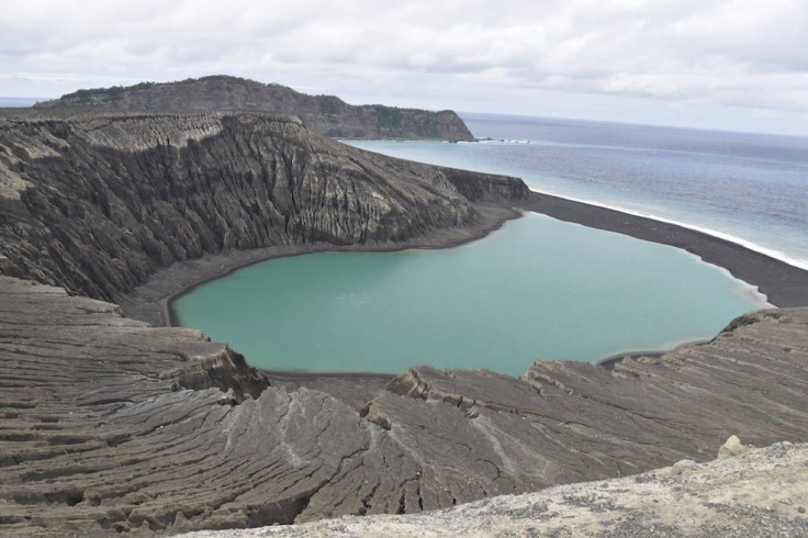
Formed in December 2015, this tiny island on the Pacific Ocean was the direct result of a submarine volcano eruption near the islands of Tonga in the South Pacific. When ash clouds and lava from the eruption settled down, it created the island that rose 400 feet above the sea surface.
The island, which was unofficially named Hunga Tonga-Hunga Ha’apai, was projected to last only a few months but latest NASA studies have shown that the island could stay for 30 years, proving an interesting area of study.
Being the first such island to form in the satellite era, it provides a unique opportunity for scientists to study the early formation of planets like Mars. Scientists think that studying the evolution of this island could provide key insights into how similar features formed on Mars.
The island holds similarities to several areas on Mars that appear to be a direct result of underwater volcanic eruptions, pointing to a past when the red planet was wet.
"Volcanic islands are some of the simplest landforms to make," said Jim Garvin, chief scientist of NASA's Goddard Space Flight Center in Greenbelt, Maryland, said in a press release on the durability of the island on the NASA website.
"Our interest is to calculate how much the 3D landscape changes over time, particularly its volume, which has only been measured a few times at other such islands. It's the first step to understand erosion rates and processes and to decipher why it has persisted longer than most people expected."
We know that Mars had frozen water at some point in its history, but a recent discovery of streaks on mountain slopes on the planet led scientists to believe that liquid water could have once flowed on it.
Now researchers finally have a miniature landmass that is a direct result of underwater volcanic eruptions they can compare to similar areas on Mars. According to the release, Hunga Tonga-Hunga Ha’apai and its neighboring islands sit on the rim of a large volcano that rises about a mile above the deep ocean floor.
Scientists believe that the shallow water around the island is similar to what existed around Martian volcanoes.
Satellites have been studying the new Tongan island allowing scientists to generate detailed maps of the shifting topography. There have also been up-close examinations to collect samples.
“In the initial months of its existence, Hunga Tonga-Hunga Ha’apai shifted in shape quickly. Initially oval, the island’s southern shore eroded rapidly, allowing the Pacific Ocean to break through into the lake at the center of the island. Steep walls around the lake appeared in danger of collapse, and it looked as if the island might have been about to vanish,” said the release.
When conditions are right during evolution of volcanic landmass, warm water turns cement-like volcanic ash into resilient rock. Scientists believe that these reactions could have occurred at both Hunga Tonga-Hunga Ha’apai and Mars. This makes studying the evolution of the newly formed island crucial to understanding Martian topography.
It is only the third such island in the last 150 years to survive more than a few months. Scientists estimate that the island could now last for decades.
If some of the volcanic shapes on Mars matched an intermediate state of Hunga Tonga-Hunga Ha’apai, scientists say that this could prove that the water disappeared and then the erosion of similar landmass stopped on Mars.“That will give us a window into some of those murkier times of Mars, when we think there were standing bodies of water,” Garvin said.
The island, which is not more than a square mile in area, has been studied extensively from both the sky and land. Satellite imagery is allowing scientists to generate detailed maps of the shifting topography of the island which they hope will give them a clearer picture of evolution of similiar landscapes.
Scientists have made visits to the island to map the surrounding seafloor and walk around for examining the rock formation up-close and collect samples. These samples will provide them with a more in-depth understanding of the rocks found on the island.
© Copyright IBTimes 2025. All rights reserved.
- MOST POPULAR IN World


