

The Next Hurricane Sandy? Hurricane Joaquin Upgraded To Category 2, Could Hit East Coast

UPDATE: 6:50 a.m. EDT -- Hurricane Joaquin strengthened to a Category 3 storm as it bore down on the central Bahamas early Thursday.
The storm is expected to turn north and northeast toward the United States late Thursday or Friday, according to the National Hurricane Center (NHC), and become a Category 4 before it hits the U.S. East Coast by the weekend.
"We've got Air Force reconnaissance planes continuously giving us data from inside the hurricane this morning, and we're going to be throwing a lot more aircraft resources at this problem over the next few days because it still is not certain whether or not Joaquin will directly impact the U.S. East Coast or stay out to sea," Rick Knabb, director of the NHC said, according to the Associated Press.
Original story:
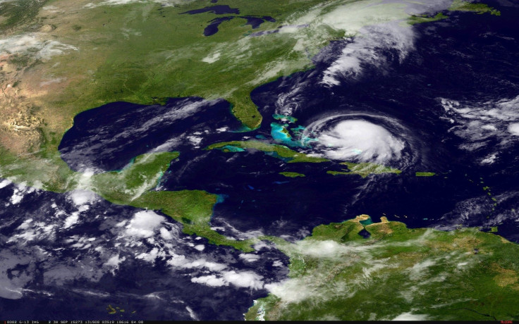
Hurricane Joaquin strengthened to Category 2 in the Atlantic on Wednesday, threatening to hit the central Bahamas on Thursday with heavy rain, the Washington Post reported. The odds of a landfall on the U.S. East Coast are increasing.
Forecasters predicted that the storm could garner even more strength and could become a Category 3 hurricane with winds 115 mph Friday and Saturday as it heads toward the East Coast. Ten to 15 inches of rain could potentially fall over central Bahamas through Friday, the U.S. National Hurricane Center said, CNN reported, and water levels could possibly rise as high as 3 to 5 feet above normal tides on the Bahamian coasts.
As of 5 p.m. EDT, a hurricane warning was in effect for the northwestern and central Bahamas, a hurricane watch was broadcasted for Bimini, and a tropical storm warning was in place for the southeastern Bahamas. Hurricane Joaquin is expected to head slowly toward the Bahamas through Thursday, but the extent of the effects on the islands will be largely dependent on how close it gets and how much time it spends nearby before making the anticipated northward turn. The worst impacts are likely to be on San Salvador in El Salvador and Rum Cay in the Bahamas, Weather.com reported.
Hurricane Joaquin is forecast to make landfall anywhere from N.C. to Delaware http://t.co/lEWrJ2r8ZS pic.twitter.com/pyRY1lX0l0
— Post Local (@postlocal) September 30, 2015Swells from the hurricane are also expected to affect the Southeastern U.S. coast by Thursday, potentially creating life-threatening rip currents. Forecasters have predicted that Joaquin will turn north after hitting the Bahamas but are unsure whether it will go left to the U.S. or right and pass Bermuda. The National Hurricane Center predicted possible landfall anywhere from North Carolina to Delaware. Regardless of whether the hurricane will hit the East Coast, portions of the region will feel the effects of the storm, including flooding, rainfall, gusty winds, high surf, beach erosion and some coastal flooding.
The last time a hurricane hit the Eastern United Sates was in 2014 when Hurricane Arthur slammed North Carolina. Hurricane Sandy wreaked havoc on the nation’s East Coast in 2012, causing catastrophic damage. Residents on the East Coast should pay close attention to the forecast now through the weekend, Weather.com advised.
© Copyright IBTimes 2026. All rights reserved.
- MOST POPULAR IN Science


