

NOAA Releases Stunning Earth, Moon Pictures Taken By GOES-16 Weather Satellite
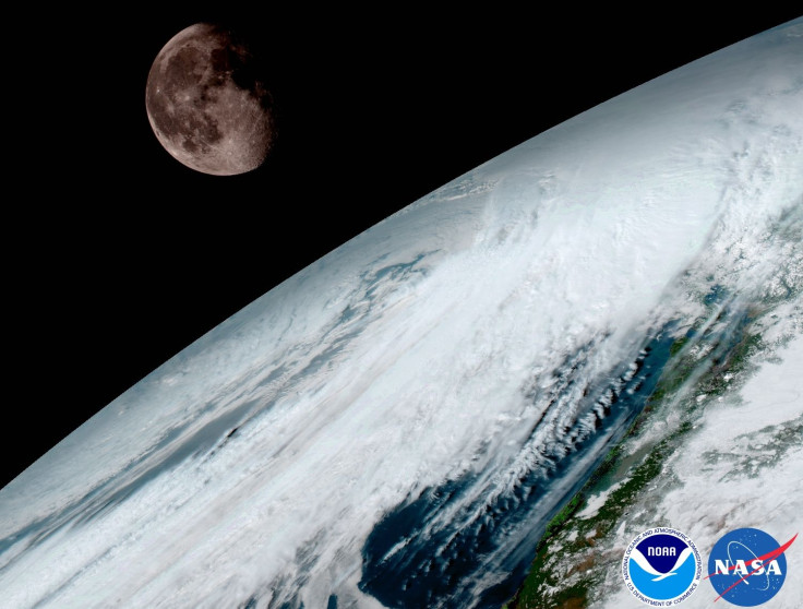
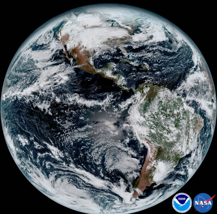
The National Oceanic and Atmospheric Administration released Monday a bunch of new photographs that show Earth (and in one picture, also the moon) as seen from space. The stunning images were captured Jan. 15 by NOAA’s newest weather satellite, GOES-16, formerly called GOES-R.
The launch of GOES-16 on Nov. 19 heralded “a new age of weather satellites. It will be like high-definition from the heavens,” NOAA said in a statement accompanying the photographs.
The onboard Advanced Baseline Imager instrument, built by Harris Corporation, took the pictures, one of which shows the full disc of our planet, specifically of the Western Hemisphere, in great detail. The imager also captured a stunning shot of the moon looking over Earth.
Stephen Volz, director of NOAA’s Satellite and Information Service, said in the statement: “This is such an exciting day for NOAA! One of our GOES-16 scientists compared this to seeing a newborn baby’s first pictures — it’s that exciting for us. These images come from the most sophisticated technology ever flown in space to predict severe weather on Earth. The fantastically rich images provide us with our first glimpse of the impact GOES-16 will have on developing life-saving forecasts.”
GOES-16 is in a geostationary orbit about 22,250 miles over the equator, and calibrates itself using the moon. Its instruments allow it to capture data at four times the spatial resolution and three times the spectral information, all of it at five times the speed, compared to earlier technology. It can provide images of the continental United States every five minutes and of Earth every 15 minutes.
The high-resolution images captured by GOES-16 (more pictures can be seen on this page) will allow scientists and weather forecasters to track and monitor phenomena such as cloud formation, atmospheric motion, land and sea surface temperatures, ocean dynamics, fire, smoke, volcanic ash plume, aerosols and air quality. Additionally, the satellite also has a transponder that will improve search and rescue operations by detecting distress signals from mariners and aviators from anywhere in the world.
The final location of GOES-16 will be announced by NOAA in May 2017, and in November, the satellite will start operating as either GOES-East or GOES-West, when it will start using all its six new instruments to gather data.
The first of its kind in the new series of weather satellites, GOES-16 will be followed by GOES-S, which, like its predecessor, was built by Lockheed Martin at its Littleton, Colorado, facility. To be named GOES-17 once it becomes operational, the launch of GOES-S is tentatively scheduled for August or later this year.
© Copyright IBTimes 2025. All rights reserved.
- MOST POPULAR IN World


