

Pacific Tropical Cyclone Lane To Hit Hawaii, 2 Others Threaten Japan, Koreas
Three tropical cyclones developed in the Pacific Ocean will hit Hawaii, North and South Korea, and Japan in the coming days, forecasts said.
All three, Lane, Soulik and Cimaron, will have wind speeds of at least 74 mph. The tropical cyclones are expected to cause high waves, rains and possible flooding in the affected areas. (Typhoons, hurricanes and cyclones are same type of phenomena; the names are given according to the area where the storms developed.)
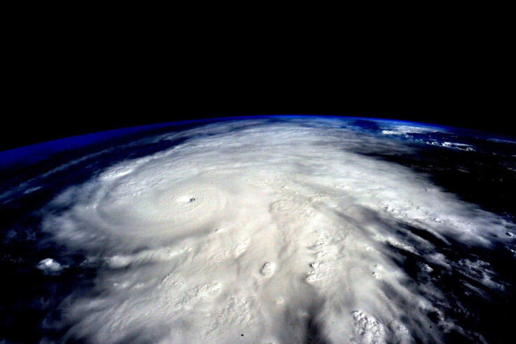
Hurricane Lane that has been gathering strength and was classified as a Category 4 hurricane on Monday and it might come dangerously close to Hawaii as the week progresses, the Central Pacific Hurricane Center (CPHC) said. Forecasts showed that at 5 p.m. local time, Monday (11 p.m. EDT), the wind speeds were at 130 mph, with an "impressive, distinct eye."
The CPHC said Hurricane Lane was, at the time of the public advisory, located at 515 miles southeast of Hilo and 720 miles southeast of Honolulu. It was moving west at a speed of 12 mph. “This general motion is expected to continue for the next day or so, with a turn more toward the northwest on Wednesday,” the advisory report said.
There might be some fluctuations in the intensity of the hurricane for the next 24 to 36 hours, and might gradually start to weaken thereafter, the CPHC predicted.
Though precise effects on the islands are still too early to be predicted, the advisory said “Large swells generated by Lane will impact the Hawaiian Islands this week. These swells will produce large and dangerous surf, as well as strong currents, along some shorelines.”
“Heavy rainfall and possible flooding associated with Lane could affect portions of the state beginning later Wednesday,” the report said. According to reports, Hawaii's Big Island might face monster waves that may reach up to 15 feet high.
According to latest reports, no coastal watches or warnings are in effect. The main Hawaiian Islands and the Northwestern Hawaiian islands are expected to be affected by the hurricane.
The other two typhoons, Soulik and Cimaron, will affect East Asia. Typhoon Cimaron is predicted to intensify through Tuesday while passing the Mariana Islands, and head toward Japan. Typhoon Soulik is predicted to impact Japan from Tuesday to Wednesday morning after which it will move to the Korean.
Typhoon #Soulik is approaching Ryukyu islands #Japan and #SouthKorea while severe tropical storm #Cimaron is headed towards #Kyoto, Japan bringing heavy #rain, strong winds and high waves. Stay informed via JMA: https://t.co/gcRV3X49eM pic.twitter.com/ktZXvvcqVU
— World Meteorological Organization (@WMO) August 21, 2018
Double trouble in the tropics for #Japan as #Typhoon Soulik and #Tropical Storm Cimaron headed toward the area with damaging winds and flooding rain threats for next week.https://t.co/2t62G30GZh pic.twitter.com/jqUYpVnDd4
— The Weather Channel (@weatherchannel) August 18, 2018
The typhoons are predicted to bring high amounts of rains, strong winds, and high waves that may reach up to 36 feet. There might be a possible chance of flooding due to the storms.
According to forecasts, Typhoon Cimaron has a maximum sustained wind speed of 74 mph with gusts of 92 mph. Typhoon Soulik has a sustained wind speed of 115 mph, with gusts up to 138 mph, according to latest forecasts.
Typhoon Soulik might cause extensive damage in North Korea especially, reports said. Path predictions show the typhoon might pass through several suspected nuclear testing sites between Thursday and Friday. The typhoon will be the first major storm to hit the Korean peninsula since 2012.
© Copyright IBTimes 2026. All rights reserved.
- MOST POPULAR IN World


