

This Satellite Image Of The Italian Coast Looks Like Art

KEY POINTS
- A NASA/USGS satellite image of the Italian coast looks like an artwork
- The visible swirls of water on the coast are caused by sediment from river water
- The sediment traces water current and eddies, making the water movement visible
Earth-observing satellites can provide important information about the things happening on our planet. But, they can also capture the art-like beauty of the Earth. Such is the image of the Italian coast captured by the Operational Land Imager (OLI) on NASA and the United States Geological Survey’s (USGS) Landsat 8 satellite.
Art-Like Satellite Image Of Italy
In the natural-color image captured by OLI, one can see colorful swirls of water off the coast of Italy, in between the mainland and the island of Elba. The swirls, which look rather like swirls of paint, are actually caused by sediments brought into the sea via several rivers. Specifically, the parts of the water with more sediment are the areas that are greenish brown in color, while the areas with less sediment can be seen in light blue.
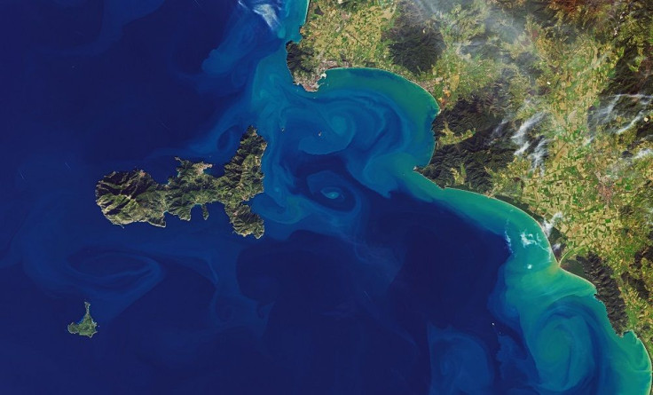
It is because of the presence of the sediment that we can see the water’s movements. In this case, we can see how the water between the mainland and Elba becomes unstable and swirls into small eddies.
Ocean scientist Aida Alvera- Azcárate of the University of Liège also shared similar images of the Italian coast captured by the European Space Agency's Sentinel-3 and Sentinel-2 satellites. She said that such small features are actually quite common in oceans and that they contribute to the total movement of water, heat and nutrients.
So today there's been a #Sentinel2 pass over eastern Italy! Part of the mini-eddy field is still there, two days after they appeared on #Sentinel3 (my previous tweet), quite long-lived for such small features! Really curious... pic.twitter.com/8hG052Cjrs
— Aida Alvera Azcarate (@aida_alvera) December 25, 2019
Infrared Swirls
Landsat 8 also captured another image of the area, at the same time, this time using its Thermal Infrared Sensor. In this false-color image, the colors that we see represent the warmth of the water in the area, with the orange and yellow areas being warmer and the blue and white areas being cooler.
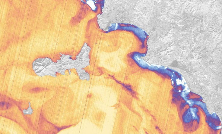
Although we can still see the beautiful swirls just like in the natural-color image, what the infrared image actually reveals is the origin of the water, especially since the river water is cooler than the sea water. For instance, the image highlights some of the cooler areas where the river water is entering the bay.
Such images, whether natural-color or infrared, help scientists better understand water movement. For instance, the infrared image highlights the water entering from Corine River into the bay but the natural-color image does not, suggesting that the river is not a major sediment contributor.
Clearly, images such as these do not just highlight the unique beauty of the Earth. But, they also help scientists better understand how it actually works.
© Copyright IBTimes 2025. All rights reserved.
- MOST POPULAR IN Science


