

Tropical Storm Arthur To Become Hurricane By Thursday; North Carolina In Projected Path: NOAA

Tropical Storm Arthur is expected to become a hurricane by Thursday as the National Hurricane Center issued a tropical storm warning Wednesday for the North Carolina coast while a tropical storm watch for the east coast of Florida was lifted.
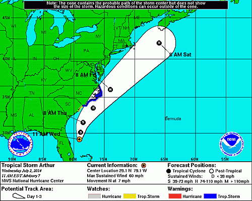
As of 11 a.m. EDT, Tropical Storm Arthur was here, or 105 miles east-northeast of Cape Canaveral, Florida, and about 260 miles south-southeast of Charleston, South Carolina, according to the National Hurricane Center in Miami. Arthur is moving at 7 mph to the north and is packing maximum sustained winds of 60 mph. Tropical storm-force winds extend up to 80 miles from the storm’s center.
Arthur is forecast to turn toward the north-northeast later Wednesday night, followed by a turn toward the northeast -- and increased speeds -- on Thursday, according to the NHC. The center of Tropical Storm Arthur is expected to pass northeastern Florida on Wednesday night and move parallel to the coasts of the Carolinas in the next 24 to 36 hours.
“Some strengthening is forecast during the next 48 hours, and Arthur is expected to become a hurricane by Thursday,” the NHC said.
An area stretching from Little River Inlet, North Carolina, to the North Carolina-Virginia border, including Pamlico Inlet and the Eastern Albemarle Sounds, is under a tropical storm warning. The designation means tropical storm conditions are expected somewhere within the area within 36 hours.
A hurricane watch is in effect for an area spanning Bogue Inlet to Oregon Inlet in North Carolina and Pamlico Sound. The watch means hurricane conditions are possible in those areas within the next 36 hours.
The area south of Little River Inlet to the South Santee River in South Carolina is under a tropical storm watch, meaning tropical storm conditions are expected in the next three days.
Between two and four feet of storm surge is expected on the North Carolina coast.
“The highest water will occur along the immediate coast in areas of onshore flow,” the hurricane center said. “The surge will be accompanied by large and damaging waves. Surge-related flooding depends on the relative timing of the surge and the tidal cycle and can vary greatly over short distances.”
Up to two inches of rain is expected to fall across the eastern coast of Florida and coastal areas of North Carolina through Thursday.
© Copyright IBTimes 2025. All rights reserved.
- MOST POPULAR IN Science


