

Earthquake Death Toll in India, Nepal Expected to Increase
Rescuers in India and Nepal looking for survivors of the 6.8 magnitude earthquake worked late into the night on Monday. Military troops dug through rubble in the Indian state of Sikkim and attempted to clear roads after a number of landslides isolated residents in the region.
The quake hit Sunday night, and the death toll has reached 74 people. More than 50 were killed and hundreds injured in Sikkim, as well as in the Indian states of Bengal and Bihar. Nine people were reportedly killed in Nepal, and another seven died in Tibet.
Rescue workers are still hoping to find buried survivors under collapsed buildings, but many fear that the death toll will continue to rise over the next few days.
The situation doesn't look good, an official from the U.N.'s disaster management team in New Delhi told Reuters. My feeling is the death toll and number of injured are going to increase.
Sikkim is India's least populated state, and the landlocked mountainous area is home to roughly 500,000 people. The small population is beneficial because it minimizes causalities and damages, but at the same time makes rescue efforts difficult due to the isolation of many residents.
None of India's 20 nuclear power plants were disturbed by the earthquake, officials said Monday. The nuclear facility closest to the quake's epicenter is the Narora Power Station, some 800 miles to the west.
Most of the damage on Sunday night and Monday morning was the result of violent landslides, and in one six-mile stretch in Sikkim, there were at least 16 landslides. The most impacted area was the city of Mangan, where buildings were destroyed, roads buckled and highways blocked due to debris.
The quake was followed by 130 after-shocks on Sunday and Monday, the highest measuring 6.1 and 5.3 magnitude on the Richter scale, according to reports.
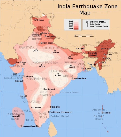
Most of Sikkim, including the capital city of Gangtok, is considered to be in Zone 4 of the Earthquake Hazard Map of India, and it's therefore designated as being in the High Damage Risk Zone. The city is also nestled between two Zone 5 (highest risk) areas to the east and west.
Earlier this month, Delhi, India was hit by a minor earthquake, sending people running from their homes. On Sept. 7, a 4.2 magnitude quake shook the city just hours after a bomb blast killed 11 and injured dozens more outside the Delhi High Court.
Delhi is also in Zone 4, but there hasn't been a major earthquake in the city's recent history.
Earthquakes in India aren't rare, but a 6.9 magnitude quake is significant. The last major quake on the India-Nepal border occurred in August 1988, when magnitude 6.8 earthquake killed 721 people, injured more than 6,000 and damaged 64,470 buildings in eastern Nepal, including the Kathmandu Valley, according to the U.S. Geological Survey.
Before that, an earthquake in 1934 in Nepal resulted in around 8,000 deaths.
India sits on the Indian Plate, a tectonic plate that has been colliding with the Eurasia Plate for about 50 million years. The Indian Plate is slowly being wedged under Eurasia, pushing up the northern plate, causing it to lift. The tectonic movement created the Himalayan Mountain range, which straddles the collision point among India, Nepal, Tibet and China.
Because of the plates' movements, the Himalayas are growing taller every year.
© Copyright IBTimes 2024. All rights reserved.
- MOST POPULAR IN World


