Four Corners Methane ‘Hot Spot’: NASA Joins Team Of Scientists Attempting To Pinpoint Source Of Gas

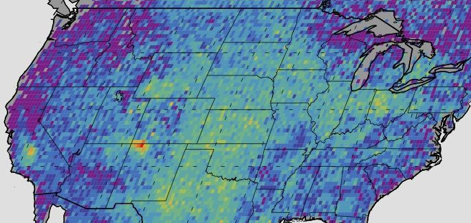
The Four Corners region in the southwestern United States -- a region where the boundaries of four states meet -- has long intrigued scientists because of its surprisingly large methane concentration. According to satellite data gathered by scientists at NASA, levels of methane in the region are more than triple the standard ground-based estimate of the greenhouse gas.
Now, a team of researchers from NASA and several other universities are attempting to unravel the mystery behind the methane “hot spot” through a series of field experiments known cumulatively as Topdown (Twin Otter Projects Defining Oil Well and Natural gas emissions). Understanding the exact forces resulting in the extraordinarily high methane emissions in the region is not just an academic exercise. Based on satellite data gathered between 2003 and 2009, the hotspot, which is centered over New Mexico's San Juan Basin, released 0.65 million tons of methane each year -- accounting for about 10 percent of yearly emissions of the gas in the country.
“With all the ground-based and airborne resources that the different groups are bringing to the region, we have the unique chance to unequivocally solve the Four Corners mystery,” Christian Frankenberg, a scientist at NASA's Jet Propulsion Laboratory in Pasadena, California, said, in a statement. Researchers from the Cooperative Institute for Research in Environmental Sciences (CIRES) in Boulder, Colorado, the National Oceanic and Atmospheric Administration (NOAA) and the University of Michigan, Ann Arbor, are also involved in the study.
As part of the experiment, scientists will fly two Twin Otter aircraft over the Four Corners area, where the borders of New Mexico, Arizona, Colorado and Utah meet. These planes will carry two instruments -- the Next-Generation Airborne Visible/Infrared Imaging Spectrometer (AVIRISng), which can be used to map methane in great detail in the entire region, and the Hyperspectral Thermal Emission Spectrometer (HyTES), which can carry out highly sensitive measurements of methane.
The two instruments will enable researchers to create a “mosaic” showing variations in methane levels every few feet, according to NASA. “If we can verify the methane detected by the satellite and identify its sources, decision-makers will have critical information for any actions they are considering,” CIRES scientist Gabrielle Pétron said, in the statement.
© Copyright IBTimes 2026. All rights reserved.
- MOST POPULAR IN Science