

Hurricane Irene Path: Destructive Storm Headed for Carolinas, Northeast
Hurricane Irene continues on its path of destruction toward the U.S., setting aim this weekend for North Carolina and the Northeast.
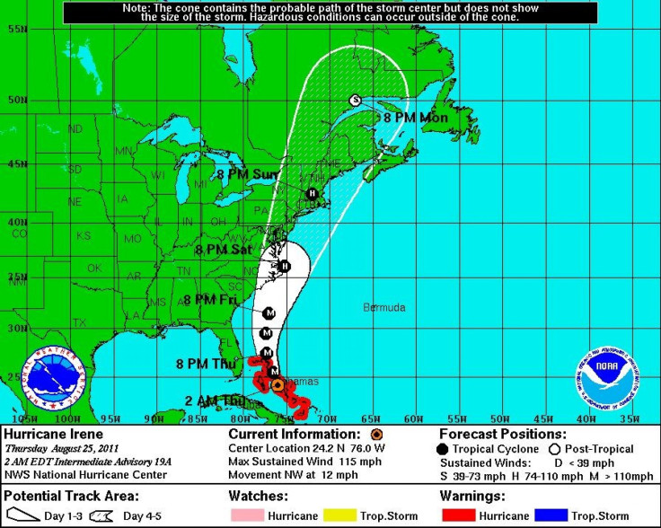
Forecasters are already calling it a potentially historic East Coast hurricane, as the likelihood of Irene battering New York and New England continues to rise.
In its 5 a.m. EDT advisory, the National Hurricane Center warned that North Carolina's Outer Banks especially could be hardhit within the next 36 hours.
Irene is now over the northern Bahamas, where it's already severely damaged homes and businesses. Wednesday night, some Bahamas residents were having difficulty finding drinking water as the storm battered the area.
Irene is currently a Category 3 storm but could get even stronger and develop into a Category 4 storm as it approaches the East Coast, according to the National Hurricane Center. If it strengthens to a Category 4 storm, it could carry a very high risk of injury or death to people, livestock and pets due to flying and falling debris, according to the National Weather Service.
There's going to be flooding, there's going to be heavy rain, National Weather Service Meteorologist Mike Rusnak told the Virginia Pilot. It's just a matter of the exact track because it's still two days out and it's still too early to try to figure out out what kind of numbers to give here.
The last big hurricane of at least Category 3 strength to strike the U.S. was Hurricane Jeanne in 2004. The last hurricane to make landfall in the U.S. was Hurricane Ike, in 2008.
The area that is expected to be hit the worst are the Carolinas, which have already begun to evacuate towns. Ocracoke Island, a tiny barrier island in North Carolina, was one of the first to ask its residents to prepare for an evacuation due to the hurricane.
The Outer Banks, a popular vacation destination, could be forced to evacuate and miss out on a potentially lucrative summer weekend. Once past the Outer Banks and the rest of North Carolina, the storm could tear all the way up the East Coast on its way to New York, according to the most recent forecasts.
Hurricane Irene won't be near its predicted Category 4 storm strength as it heads towards New York over the weekend, but it will still deliver heavy rainfall, high speed winds, and other nasty effects on the area.
Go ahead and make sure you're ready and then if evacuations are required, heed those evacuation orders, Craig Fugate, manager of FEMA, told ABC News. The Hurricane Center says this storm is going to grow and strengthen ... and it's really something people need to be prepared now for so they can be ready if they have to act.
Northeast residents can expect remnants of the hurricane to hit New Jersey by Sunday afternoon, before it continues to make its way up to New York and New England, according to forecasters.
There's a lot of uncertainty with the track right now, Al Cope, a meteorologist with the National Weather Service's Mount Holly office, told the Star Ledger. The center could be off the coast of New Jersey by Sunday afternoon.
From New Jersey, it could make landfall in New York by Sunday evening and continue to pound the area through Monday.
Current models show that the hurricane could hit the New York area with winds in excess of 70 miles per hour, though the storm's path changes frequently and it's conceivable that the storm could be pushed away and miss the entire Northeast. But as of right now it looks like as strong as a Category 2 storm could hit the New York area.
CBS News hurricane consultant David Bernard said the hurricane could cut across Long Island as a large Category 2 storm, which would result in massive power disruption and tremendous wind damage will result.
Bernard said that the push out to sea option is fading away fast.
The New England and Long Island areas have historically been remiss of hurricanes. According to the Weather Channel, only 10 hurricanes have come within 75 miles of Boston since 1851, with Hurricane Bob approaching the area in 1991.
The last hurricane to hit Long Island was Hurricane Gloria in 1985, but the area is preparing for Irene.
It looks like Long Island will be impacted in some way by this system, whether it's a hurricane or not when it gets here, said meteorologist Brian Ciemnecki of the National Weather Service to Newsday.
Potential Hurricane Damage
As Irene makes its way towards the United States, insurance companies look on with elevated concern over the potential damage that it could cause. Kinetic Analysis Corp. estimates the storm has caused $3.1 billion in damage in the Caribbean already.
While the strength is clearly important, it's the area of impact that could most factor into the amount of economic damage.
It really depends on where it makes landfall, Chris Hackett, the Director for Personal Line Policy for the Property Casualty Insurers Association of America, told the IBTimes. If it makes landfall right in Miami where there are a lot of high-rise condominiums the damage will be a lot more expensive than if it hits a rural area in Georgia or in the Carolinas.
Hackett said that insurers are likely tracking the hurricane and following where scientists and meteorologists are predicting the hurricane will hit. Once insurers know impacted locations, they can send mobile catastrophe units to help people as soon as possible after a disaster.
Wherever it does hit, insurers definitely take it very seriously in trying to be as responsible to policy holders as they can be, he added.
© Copyright IBTimes 2025. All rights reserved.
- MOST POPULAR IN Society


