

Hurricane Irene Path Update: Landfall in NC with Tornado Spotted [Latest Map and Warnings]
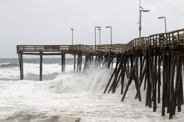
As Hurricane Irene sustains its path, making landfall in eastern North Carolina at around 7:30 a.m. Saturday, the storm has weakened from Category 2 to Category 1, according to the latest update released by the National Hurricane Center (NHC) at 5 a.m. Saturday.
Despite the downgrade, Irene remains extremely dangerous, said forecasters.
Hurricane Irene did weaken overnight, currently packing maximum sustained winds of about 90 miles per hour with higher gusts, but the storm is large, with catastrophic flooding potential on its coastal path, and it has also slowed down, enhancing impact even as winds slow.
Saturday morning, Irene smashes into North Carolina coast with 80 mph. A tornado was spotted in Beaufort and Tyrrell counties, North Carolina, according to the NHC.
Irene's projected path remains the same, urging major metropolitan areas including Boston, New York, Hartford, and Philadelphia to prepare for the worst.
States of emergency have been declared all along the east coast, and mass transit systems are shutting down Saturday in New York, New Jersey, and in Philadelphia.
Over 30 million U.S. East Coast residents are under Hurricane Warning while 2.5 million are under evacuation orders.
According to the 5 a.m. update, watches and warnings currently in effect for these regions:
Hurricane Warning
Little River Inlet North Carolina northward to Sagamore Beach Massachusetts, including...
the Pamlico
Albemarle
Currituck Sounds
Delaware Bay
Chesapeake Bay south of Drum Point
New York City
Long Island
Long Island Sound
Coastal Connecticut and Rhode Island
Block Island
Martha's Vineyard
Nantucket
Tropical Storm Warning
South Santee River, South Carolina to Little River Inlet, Chesapeake Bay from Drum Point Northward and the Tidal Potomac, north of Sagamore Beach to Merrimack River.
Tropical Storm Watch
Merrimack River to Eastport Maine
New York City remains directly in the path of Irene on Saturday, and has issued an unprecedented evacuation order as well as transit shutdown for the weekend.
Later Saturday night and Sunday will see the worst conditions for the New York City area, with hurricane conditions likely including destructive wind, heavy flooding rain, and storm surge with coastal flooding.
If winds reach 60 miles per hour for a while, bridges including the George Washington Bridge, the Robert F. Kennedy Triboro Bridge, the Throgs Neck Bridge and the Whitestone Bridge will be closed, according to Governor Andrew Cuomo.
Officials also elected to shut down New York City's sprawling transit system, which encompasses both the subway and an array of commuter rail lines that serve Long Island, Westchester County and Connecticut, starting on Saturday until Monday.
With the New York Cit Hurricane Evacuation Zones map, you can see whether you live in an evacuation zone, and find shelter or evacuation center.
The big safety concern is for winds above 74 mph (map 3). The following is the Saffir-Simpson Hurricane Scale from the Federal Emergency Management Agency (FEMA) that shows the potential damages of such winds.
Below is the map released by the NHC at 5 a.m. Saturday.
This graphic shows an approximate representation of coastal areas under a hurricane warning (red), hurricane watch (pink), tropical storm warning (blue) and tropical storm watch (yellow). The orange circle indicates the current position of the center of the tropical cyclone.
© Copyright IBTimes 2024. All rights reserved.
-

Microsoft Expands Its AI Empire Abroad
-

Oil: 'Mother Of Corruption' In Venezuela
-

'Extreme' Climate Blamed For World's Worst Wine Harvest In 62 Years
-

Macron Warns 'Mortal' Europe Needs Credible Defence
-

Bitcoin And Crypto Price Review - Another Myth Gets Busted?
-

Mass Cancellations Loom Despite French Air Union Cancelling Strike
-

Mired In Crisis, Boeing Reports Another Loss
-

Recycled 'Zombie' Misinformation Targets US Voters
-

Hackers Leak Part Of Source Code Of El Salvador's Bitcoin Wallet
-

Azerbaijan Says 'Closer Than Ever' To Armenia Peace Deal Amid Border Talks


