

Hurricane Maria 2011: Newfoundland Braces for Heavy Wind, Rain

Hurricane Maria barreled toward Newfoundland's Avalon Peninsula Friday afternoon as a Category 1 hurricane with maximum sustained winds of 75 mph.
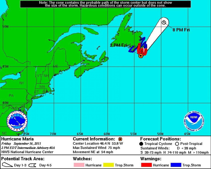
Heavy rain and strong wind gusts approached the coast with the eye of the storm located 40 miles west-southwest of Cape Race, Newfoundland, according to a 2 p.m. EDT alert from the National Hurricane Center in Miami.
Maria is moving northeast at 54 mph and is expected to make a gradual increase in forward speed throughout the afternoon and evening Friday as the storm passes over the Canadian Maritimes.
A hurricane warning remains in effect for Newfoundland from Arnolds Cove to Brigus South, while tropical storm warnings are in effect for Newfoundland from Stones Cove to Arnolds Cove and Brigus South to Charlottetown.
Hurricane-force winds extend outward up to 45 miles from the storm center and tropical-storm-force winds stretch out nearly 275 miles, mostly to the east of the storm center.
While hurricane conditions are possible in the warning area Friday afternoon, they'll most likely be confined to the coastal waters southeast. Most of Newfoundland can expect tropical storm conditions and rainfall totals between one and three inches. The rain totals should be less than originally predicted because the storm is moving quite fast. The largest concerns, however, will be coastal flooding and a strong storm surge.
Environment Canada expects wind gusts of up to 87 mph and Canadian Buoy 44138 recently reported a peak gust of 79 mph.
Hurricane Maria is expected to weaken after crossing Newfoundland and lose its tropical characteristics by Friday night. By Saturday, the storm will likely be absorbed within a frontal zone.
Maria comes just one year after Hurricane Igor tore apart infrastructure on Newfoundland, leaving dozens of communities in states of emergency. Igor was the most powerful storm on record to strike the island, packing maximum sustained winds of 85 mph. The hurricane made landfall near Cape Race on Sept. 21, 2010, dumping nearly eight inches of rain that washed out roads, knocked out hydroelectric power, and toppled many trees.
Fast forward to 2011, and the island is beginning to feel the brunt of yet another rare hurricane.
There is the possibility of some trees being blown down, large branches and the inevitable utility lines coming down. If the storm tracks exactly as we predict right now, [Newfoundland] certainly can expect some damaging winds, Chris Fogarty, program supervisor for the Canadian Hurricane Centre, told CBC News.
The storm was not expected to have much impact on Newfoundland's offshore oil platforms and vessels as Maria's rapid forward speed will prevent her from churning up the waves beyond 20 feet on the Grand Banks.
Schools across much of southern Newfoundland were closed and there was relatively little traffic in downtown St. John's, the province's capital and largest city.
© Copyright IBTimes 2024. All rights reserved.
- MOST READ


