

Katia Path Shaping Up as Another Earl; Tropical Storm Lee Flooding Threat High Along Gulf Coast
Hurricane Katia is maintaining strength and direction on Friday, and while a direct strike on the U.S. is not highly likely at this time, the storm could still take a path similar to what Hurricane Earl did last year, with impact along the East Coast without making landfall late next week.
Also, a U.S. strike remains a possibility since storm forecast models so far in advance high a high margin of error.
Meanwhile, Tropical Storm Lee is drenching the U.S. Gulf Coast, with the worst yet to come. One weather expert said Lee could cause $1 billion in damage along the coast and inland into Louisiana and Mississippi with flooding.
Katia is moving toward the northwest near 10 miles per hour, with maximum sustained winds of 75 miles per hour. On the forecast track, Katia will pass well north of the Leeward Islands on Sunday, and no significant change in speed or direction is expected in the next few days.
After Katia clears a small band of strong winds in the storm's path in the next few days, it will likely strengthen, perhaps to Category 3 status next week. Also, Katia is not expected to threaten any land mass through early next week.
But there are growing signs Katia will track further west next week as the storm strengthens, before making a right turn due to steering, strengthening westerly upper level winds across the mid and upper U.S. next week. How far west Katia pushes is the wild card in terms of impact to the U.S.
If the storm pushes further west as some models are now indicating, Katia could impact the East Coast from the Carolinas to New Jersey as Earl did in 2010, without making a direct strike on land.
Katia became the 11th named storm of the Atlantic hurricane season which runs from June 1 to Nov. 30. Irene became the first to reach hurricane strength, before ravaging a path up the East Coast last week, and power remains out in some areas and the cleanup may take weeks, if not months for some.
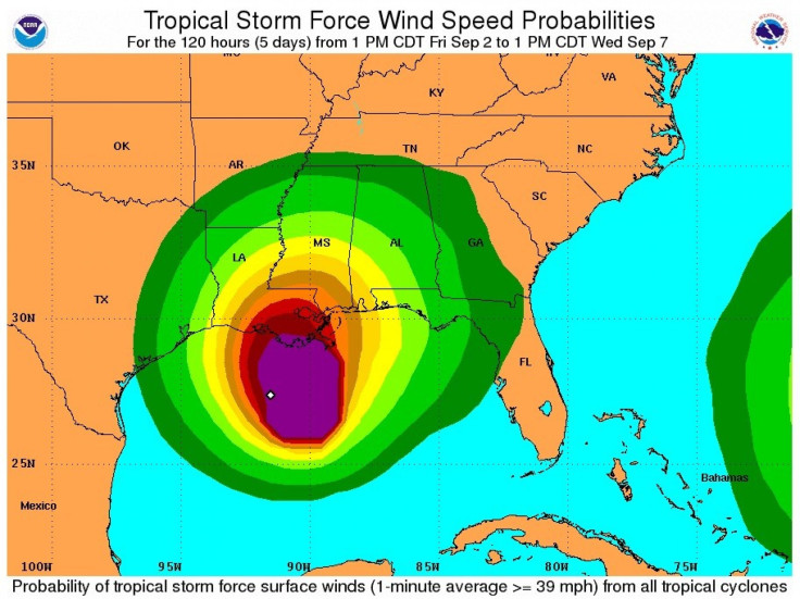
On the Gulf Coast, Tropical Storm Lee will pound the Gulf Coast today and into the weekend, putting levees in New Orleans that breached during Katrina at risk before eventually spreading heavy rains and flooding risks from the coastal region up through the Appalachians.
Rain from New Orleans to Mississippi has been relentless since Friday morning as steady downpours mix with gusty winds of up to 40 miles per hour as Lee approaches from the south on a slow moving, impacting path. Tropical storm warnings are in effect from Pascagoula, Miss. across the coast to Sabine, Texas.
Tornado watches and warnings have been posted throughout the region but no tornadoes have touched down so far, according to reports. Louisiana Gov. Bobby Jindal has declared a state of emergency in 10 parishes, and Mississippi has declared a state of emergency for its coastal counties.
Forecasts call for some areas of the coastal region including New Orleans to get as much as 20 inches of rain -- that's five more than New Orleans got in Katrina, when levees breached from Lake Pontchartrain, flooding the city and claiming hundreds of lives.
The bottom line for folks is to know regardless of what they call it, if you live in south Louisiana, especially southeast Louisiana, you are going to see a lot of rain between now and Tuesday, Jindal told ABC.
Tropical Storm Lee is expected to make landfall along Louisiana's central coast today, before moving toward New Orleans. Wind speeds aren't the biggest concern, though Lee has gained strength, with sustained winds approaching 60 miles per hour.
Rather, Lee poses significant risk to the region because it is moving slow and drenching the region, and flooding is expected to be severe in some areas. Also, while Lee doesn't pack a hurricane punch at its core, the storms wind and rains extend far.
Tropical storm force winds and heavy rains are spread out all the way from Louisiana to Alabama and almost into northwest Florida, said National Hurricane Center specialist Eric Blake.
The threat level from tropical storm Lee from the northern Gulf Coast to the Tennessee Valley is medium to high, according to The Weather Channel, with significant impacts from continual flooding rains.
Flooding is a huge concern from the Gulf Coast to the Southern Appalachians...locally 20 of rain is not out of the question near the Gulf coast! The Weather Channel reports.
Persistent onshore wind flow could lead to significant coastal flooding along the northern Gulf coast, while high surf and rip currents are dangerous threats to Labor Day weekend beach goers. Lee's wind threat is low, but that could increase if Lee intensifies in the warm gulf waters.
Lee is so slow moving, the storm will likely remain in Louisiana Labor Day morning, north of Louisiana and approaching Mississippi, with winds of 45 miles per hour, according to forecasts. The storm is expected to move slow through Mississippi, Alabama and Tennessee, reaching the Huntsville and Chattanooga region early Wednesday morning, with heavy rain and gusting winds.
In New Orleans, officials have posted online a list of streets prone to flooding, and the city has swift-water rescue teams on alert. Authorities are confident, however, New Orleans' revamped levee system will hold during Lee. The system has recently undergone a multi-billion dollar upgrade after Hurricane Katrina flooding in 2005.
Alex Sosnowski, a senior meteorologists at AccuWeather.com, wrote Friday that the storm has the potential to be the next billion-dollar disaster for the U.S., by way of epic flooding.
By Friday evening, New Orleans had received two-and-a-half inches of rain, but more is expected. So far, however, it could be worse, according to one resident.
It's a lot of rain. It's nothing, nothing to Katrina, Malcolm James, 59, a federal investigator in New Orleans who lost his home after levees broke during Katrina in August 2005 and had to be airlifted by helicopter, told the Associated Press.
This is mild, he said. Things could be worse.
© Copyright IBTimes 2024. All rights reserved.
-

Taiwan Hit By Dozens Of Strong Aftershocks From Deadly Quake
-

Gaza Health System 'Completely Obliterated': UN Expert
-

In Ecuadoran Amazon, Butterflies Provide A Gauge Of Climate Change
-

50 Years On, Vintage Vehicles To Reenact Portugal's Carnation Revolution
-

Conflicts Push Military Spending To 'All-time High': Report
-

'Thank You, America:' Zelensky And Netanyahu Applaud House Passage Of Foreign Aid Package
-

Women Journalists Bear The Brunt Of Cyberbullying
-

US Aid Shows Ukraine Will Not Be 'Second Afghanistan': Zelensky
-

Elon Musk's X Fights Australian Watchdog Over Church Stabbing Posts
-

Ukraine, Israel, TikTok: The Massive Aid Package Before US Congress


