

NASA’s Mars Reconnaissance Orbiter Makes 50,000th Orbit, Continues Red Planet Exploration
NASA’s Mars Reconnaissance Orbiter (MRO), which has been studying the red planet since late 2006, completed 50,000 orbits around Mars on March 27, NASA announced Wednesday. Photographs taken so far by the Context Camera (CTX) aboard the spacecraft now cover an unprecedented over 99 percent of the planet.
CTX strikes a balance between high resolution and image size, taking photographs that show about 20 feet (6 meters) of the Martian surface in every pixel. The camera has so far captured about 90,000 images, each of which can show features smaller than a tennis court in a patch of ground about 18.5 miles (30 kilometers) across.
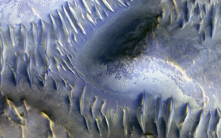
Read: Mars Orbiter Shows Sand Dunes On Red Planet
“Reaching 99.1-percent coverage has been tricky because a number of factors, including weather conditions, coordination with other instruments, downlink limitations, and orbital constraints, tend to limit where we can image and when,” CTX team leader Michael Malin of Malin Space Science Systems, San Diego, said in a statement.
via GIPHY
Over 60 percent of the total surface of Mars, which in its entirety is just slightly less than the entire landmass of Earth taken together, has been imaged twice by the instrument.
“Single coverage provides a baseline we can use for comparison with future observations, as we look for changes. Re-imaging areas serves two functions: looking for changes and acquiring stereoscopic views from which we can make topographic maps,” Malin added.
Some of the repeat observations, such as over 200 images of a fresh impact crater, allow scientists to study the rate at which small asteroids collide with Mars. Some impacts reveal a white substance, interpreted as water ice, and analysis of that provides evidence for water ice buried near the Martian surface.
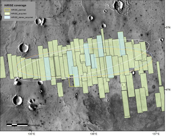
There are two other cameras on the MRO — the High Resolution Imaging Science Experiment (HiRISE), which has a much higher resolution than CTX and has covered about 3 percent of Mars, and the Mars Color Imager, which observes almost the entire planet daily for weather changes. A fourth instrument, the Mars Climate Sounder, keeps a record of the temperatures and suspended particles in the Martian atmosphere.
Launched on Aug. 12, 2005, MRO reached its initial orbit around Mars in March 2006, but began operations from its two-hour near-polar orbit in November 2006. Other than its scientific missions, it is also helping NASA finalize the landing site for 2018 InSight mission, as well as serving as the communications relay for both the Curiosity and Opportunity rovers.
“After 11 and a half years in flight, the spacecraft is healthy and remains fully functional. It’s a marvelous vehicle that we expect will serve the Mars Exploration Program and Mars science for many more years to come,” MRO project manager Dan Johnston at NASA's Jet Propulsion Laboratory, Pasadena, California, said in the statement.
© Copyright IBTimes 2024. All rights reserved.
-

Self-care: Orangutan Seen Apparently Treating Wound
-

European Court Upholds Italy's Claim To Greek Bronze In US Museum
-

Colombian School, A Grim Reminder Of Atrocities Of Rubber Fever
-

More War Debris In Gaza Than Ukraine: UN
-

UK Confirms First Migrants Held For Rwanda Deportation Flights
-

Tesla To Cut Hundreds More Jobs In Musk Cost Push: Report
-

Microsoft Is Turning Into The 'Maestro' Of AI Transformation
-

US-Japan-Philippines Alliance: A Trio With Bitter Past Now Threatens China's Maritime Ambitions
-

Abu Dhabi-backed Group Ends Telegraph Takeover Bid
-

New Post-Brexit Controls: A Thorn For UK Horticulture


