

Storm Alberto: Heavy Rain, Flash Floods Expected Along Lousiana, Florida Coast

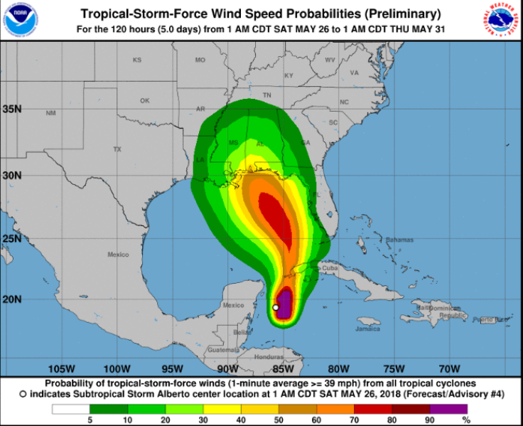
The first named tropical weather system of the 2018 – subtropical storm Alberto - was located about 85 miles southeast of Cozumel, Mexico, sustaining winds of 40 miles an hour, Friday afternoon.
According to the Weather Channel, Alberto was moving eastward at 2 miles an hour in the western Caribbean Sea, and was expected to head north through the Gulf of Mexico over the Memorial Day weekend, bringing possibility of tornadoes, flash flooding, rip currents, strong winds and coastal flooding in the northern Gulf coast.
Although the center of the storm was located off the southern coast of Mexico's Yucatán Peninsula, there remained a possibility of it shifting to the western tip of Cuba overnight.
Hence, a tropical storm watch was issued for the Gulf coast from Louisiana to Florida, parts of Yucatan peninsula in Mexico, including Tulum, and western Cuba.
The National Hurricane Center defines a subtropical storm as “a subtropical cyclone in which the maximum sustained surface wind speed (using the U.S. 1-minute average) is 34 kt (39 mph or 63 km/hr) or more.” They have the potential to eventually develop into tropical storms and hurricanes.
Subtropical storm Alberto was officially announced a day after the National Oceanic and Atmospheric Administration (NOAA) released their hurricane season forecast for 2018. In the report, meteorologists expected an active Atlantic hurricane season with at least 10 to 16 major storms, with five to nine hurricanes, out of which, one to four could have sustained winds of at least 111 mph.
On Thursday, NOAA tweeted:
1:05 AM New Special Tropical Weather Outlook issued- There is a high chance (90%) of a subtropical or tropical cyclone forming in the central or eastern Gulf of Mexico this weekend. Heavy rain and rip currents are the main threats for now. Full details: https://t.co/m9946DGzPQ pic.twitter.com/mCkOHSXihI
— National Hurricane Center (@NHC_Atlantic) May 25, 2018
Effects
The northeastern portions of the Yucatan Peninsula and western Cuba are expected to receive 25 inches of rain, while four to eight inches and a maximum of 12 inches are possible across the Florida Keys and southern and southwestern Florida, CBS News reported.
Effects of the subtropical storm along the central Gulf Coast region and the southeastern United States are expected to begin during the weekend and continue into early next week.
The water could reach two to four feet above land from Horseshoe Beach in northern Florida to the mouth of Mississippi River, where a storm surge watch has been issued.
Chances of flooding would increase over the next week when the subtropical storm begins to slow down after it moves inland. Weather experts have warned rainfall could bring extreme flash floods and mudslides.
Areas like the western areas of Cuba and the eastern coast of Mexico's Yucatan Peninsula can experience surf swells that can lead to dangerous surf and rip current conditions. Similar weather conditions are also forecast for central and eastern U.S. Gulf Coast.
As a reminder, there is a HIGH Risk of Rip Currents starting tonight and lasting through the start of next week.
— NWS Mobile (@NWSMobile) May 24, 2018
Be very aware of the hazard this weekend and Be Safe. pic.twitter.com/nA9hyUDE6J
Also, a threat of tornadoes lingers from Sunday to early Tuesday near the northern Gulf Coast.
© Copyright IBTimes 2024. All rights reserved.
-

Former US Ambassador Asserts Taiwan Will Receive Support From Trump If He Wins
-

Heatwave Hammers Thailand's Stinky But Lucrative Durian Farms
-

Vietnam Temperature Records Tumble As Heatwave Scorches
-

Self-care: Orangutan Seen Apparently Treating Wound
-

European Court Upholds Italy's Claim To Greek Bronze In US Museum
-

Colombian School, A Grim Reminder Of Atrocities Of Rubber Fever
-

More War Debris In Gaza Than Ukraine: UN
-

UK Confirms First Migrants Held For Rwanda Deportation Flights
-

Tesla To Cut Hundreds More Jobs In Musk Cost Push: Report
-

New Post-Brexit Controls: A Thorn For UK Horticulture


