Tropical Storm Chantal Expected To Reach Hurricane Strength Before Hitting Haiti, Dominican Republic

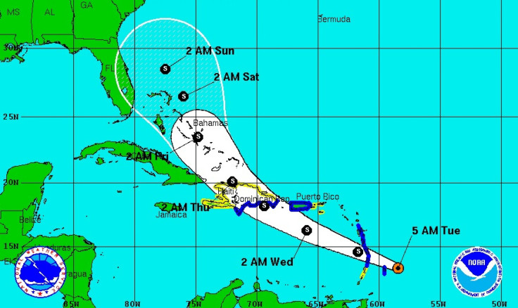
The National Hurricane Center in Miami said early Tuesday that Tropical Storm Chantal will pass over the small islands of the Lesser Antilles en route to the Dominican Republic. The most recent data indicates that the storm was centered about 155 miles (250 kilometers) east of Barbados at 2 a.m. with maximum sustained winds of 50 mph and was moving west-northwest at 26 mph.
Chantal was expected to move over the small islands on the eastern rim of the Caribbean early Tuesday and be near the Dominican Republic on Wednesday, according to the Hurricane Center.
While the center said that Chantal has the potential to reach hurricane strength before it gets to Hispaniola, the island shared by the Dominican Republic and Haiti, a tropical storm would probably be enough to provoke flooding and landslides as both countries are vulnerable to even the slightest weather conditions.
U.S. forecasters expect that wind shear and interaction with the mountains of Hispaniola and Cuba will cause Chantal to start weakening in about three days and it is expected to be a tropical depression Friday while over the Bahamas.
In St. Lucia, the government ordered a midday closure of all schools until Wednesday. The director of the local meteorological office warned that parts of the island could potentially be impacted by landslides and flooding.
As of Tuesday, tropical storm warnings have been put in place for St. Lucia, Barbados, Dominica, Martinique, Guadeloupe, Puerto Rico and the southern coast of the Dominican Republic from Cabo Engano to the border with Haiti.
Tropical storm watches are also in effect for Haiti, St. Vincent, the U.S. Virgin Islands, Vieques and Culebra, and the northern coast of the Dominican Republic from north of Cabo Engano to Cabo Frances Viejo.
© Copyright IBTimes 2025. All rights reserved.


