

What Are Grabens? ESA Releases 3D Image Of Fractures On Mars Crust

European Space Agency’s (ESA) Mars Express, which is its first planetary mission, captured in March fractures on the surface of the red planet that stretches thousands of miles in length in the Sirenum Fossae region in the southern hemisphere. A series of high-definition images of the fractures, including a 3D image, were recently released by ESA.
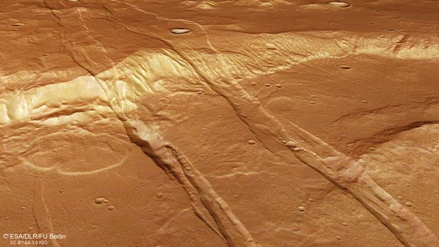
The High Resolution Stereo Camera operated by the German Aerospace Center (Deutsches Zentrum für Luft- und Raumfahrt), which was on board the ESA Mars Express spacecraft captured a region of the red planet strongly shaped by volcanic activity. Traces of this activity included the striking parallel grabens that cross the region stretching across a belt of heightened volcanic activity in the past.
Grabens are nothing but small indentations on a planet’s crust. When a strip of land displaces downwards, it causes raised embankments on each side. They are formed due to tensional forces that cause the crust to stretch. Grabens are usually accompanied by another geological defect called the horst. The horst is the elevated structure on either side of the fault. These horsts are pushed upwards and the grabens pushed downwards, creating the structure that is visually very similar to low-lying areas such as rifts and river valleys. Horsts represent the ridges between or on either side of these valleys.
These fractures on the surface cause the area nearby to divide into blocks, according to a release on ESA’s website. The stretching and movement of the crust due to volcanic activity cause a pair of faults to drop down into grabens, which are several kilometers wide and a few hundred meters deep.
Elevated blocks of crust remain between two graben when the faults occur parallel, causing a series of crests and troughs.
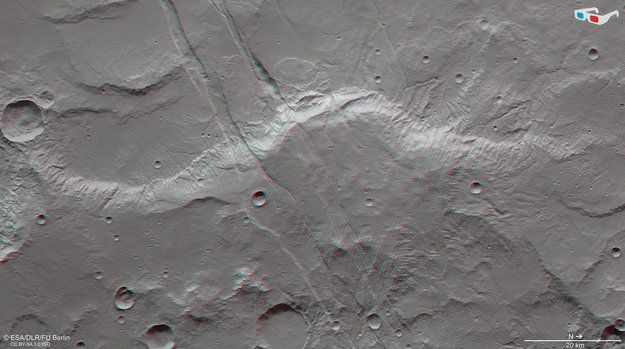
The Sirenum Fossae are part of a larger radial fracture pattern around the Arsia Mons volcano in the Tharsis region, which is situated some 1800 km to the northeast.
“Tharsis is the largest volcanic province on Mars, its far-reaching fracture system testament to the powerful influence this impressive volcanic province had on the planet,” the release added.
The Sirenum Fossae fracture system found by Mars Express can be associated with tectonic stress arising from ancient volcanic activity in the Tharsis region. There are many theories on how the graben could have formed. For example, the graben could be caused by the “planet’s crust stretching apart as a magma chamber bulges the crust above it, or alternatively as the crust collapsed along lines of weakness as the magma chamber emptied.”
There is also a possibility each graben was associated with an ancient volcanic dike. This is a steep passageway that runs within rocks, which helped magma from the interior of Mars to propagate upwards. The heat during the rise could have caused cracking along the surface.
These dike swarms are also seen on Earth in places like Iceland in the Krafla fissure swarm.
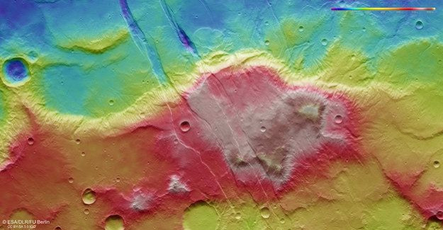
The release said studying geological features like grabens that cuts into the surface of the planet provide an important window to study the interior of the planet.
For example, NASA’s Mars Reconnaissance Orbiter identified gullies on some of the steep slopes in Sirenum Fossae, along troughs and in the rims of impact craters. What material carves out the small channels is a topic of active research: they were initially thought to be related to flowing water, but recent proposals suggest seasonal frozen carbon dioxide — dry ice — levitating downslope may be responsible.
© Copyright IBTimes 2025. All rights reserved.
- MOST POPULAR IN World


