

Afghanistan Earthquake: Hindu Kush Tremor Underscores South Asia’s Violent Seismic History

Monday’s earthquake in South Asia, which sent tremors across parts of Afghanistan, Pakistan and northern India, was just one of the many that frequently shake up the region. While most quakes that strike the seismically-active junction of the Indian and the Eurasian Plate are minor, and have not led to a significant loss of life and property, three of them -- in 2001, 2005 and in April this year -- have been particularly devastating, killing a total of nearly 120,000 people.
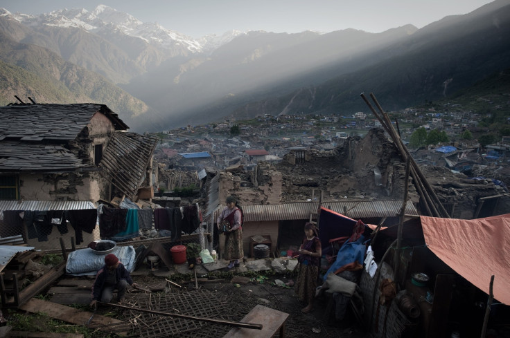
Most recently, exactly six months back, a magnitude-7.9 earthquake struck Nepal -- the country's worst on record. Over 9,000 people died in the impoverished nation and the survivors are still struggling to recover and rebuild their lives. Monday’s earthquake -- which had its epicenter in northeastern Afghanistan -- also sent tremors through parts of Nepal, including in the capital city of Kathmandu -- where more than 1,000 people still live in makeshift camps.
Earthquake felt here in Kathmandu. Strong enough to send us out of the building.
— Rubeena Mahato (@rubeenaa) October 26, 2015Over 10 years ago, on Oct. 8, 2005, a 7.6-magnitude earthquake shook the Jammu and Kashmir region -- a disputed territory controlled by India and Pakistan -- along with several provinces in Pakistan, India and Afghanistan. The disaster, classified as one of the most destructive earthquakes in recent decades, left approximately 80,000 people dead and millions homeless.
And, in 2001, an earthquake in the Indian state of Gujarat -- which lies nearly 250 miles from the Indian and Eurasian Plate boundaries -- was struck with a 7.7-magnitude earthquake that left an estimated 20,000 people dead.
The region owes its violent seismic history to the movement of the Indian Plate in the south against the Eurasian Plate in the north. Approximately 225 million years ago, India was a large island still situated off the Australian coast -- separated from the Asian continent by a vast ocean. When Pangaea -- a prehistoric supercontinent -- broke apart about 200 million years ago, India began to move northward. And, about 40 million to 50 million years ago, it began to collide against the Eurasian Plate -- a movement that created the Himalayas.
According to the U.S. Geological Survey (USGS), this movement is still continuing, increasing the height of the Himalayas by up to 0.4 inches a year and making the region a hotbed of powerful earthquakes.
“Some models suggest the presence of two subduction zones; with the Indian plate being subducted beneath the Hindu Kush region and the Eurasian plate being subducted beneath the Pamir region. However, other models suggest that just one of the two plates is being subducted and that the slab has become contorted and overturned in places,” the USGS said, in a statement describing the seismotectonics of the Himalayan region and its vicinity.
The volatile tectonics of the region has also led some scientists to suggest that a “great Himalayan earthquake” -- one bigger than magnitude 8 -- is increasingly likely to hit the region by the end of the century.
© Copyright IBTimes 2026. All rights reserved.
- MOST POPULAR IN Science


