

California Kincade Fire Damage Visible From Space, NASA Reveals Photo
The latest image captured by NASA’s orbiting satellite shows the level of destruction left by the Kincade Fire in California. The photo taken from space shows the massive area destroyed by the wildfire.
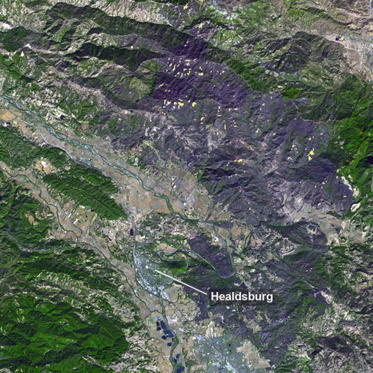
The image was taken by NASA’s Terra satellite through its onboard Advanced Spaceborne Thermal Emission and Reflection Radiometer (ASTER) instrument. The satellite was officially launched in December 1999. Using its thermal infrared imaging capabilities, Terra has been monitoring the changes on Earth’s surface ever since its launch.
In the photo, which was taken on Nov. 3, the large patches of dark gray areas represent the regions affected by the wildfire. Certain spots where fires are still active are shown as yellow dots in the photo.
According to NASA, after burning almost 78,000 acres of land, the Kincade Fire is now almost contained.
“After starting on Oct. 23, forcing residents to evacuate, the fire had burned 77,758 acres and destroyed 372 structures by Nov. 3, according to the California Department of Forestry and Fire Protection,” the agency said in a press release. “It is now over 80% contained.”
Thousands of acres damaged by the ongoing Kincade Fire in Northern California are visible in this recent @NASAEarth satellite image. The fire had burned almost 80,000 acres & destroyed hundreds of structures by Nov. 3, and is now over 80% contained. More: https://t.co/UGcnsC95sH pic.twitter.com/B23dr85Q1Q
— NASA (@NASA) November 6, 2019
This isn’t the first time NASA shared photos of the wildfire’s devastation taken from space. Last week, astronaut Andrew Morgan was able to photograph the Kincade Fire as it ravaged across California while he was aboard the International Space Station.
“I was able to catch these pictures of the California wildfires burning north of the Bay Area,” Morgan wrote on Twitter. “Thinking of the people who have lost their homes and the brave first responders on the front lines protecting them.”
According to NASA, winds in northern California were mainly responsible for the immediate spread of the Kincade Fire. In a previous statement, the agency also noted that the yearly increase in average global temperatures also plays a huge role in the worsening condition of wildfires. NASA revealed that due to these factors, incidents involving wildfires have spiked drastically within the last five years.
“A study published in July 2019 shows these remarkable fire years are no longer freakish anomalies,” NASA said in a statement. “They fit with a trend of more frequent and bigger fires. According to the researchers, the annual burned area across California has increased fivefold over the past five decades, and the main driver is higher temperatures.”
© Copyright IBTimes 2025. All rights reserved.
- MOST POPULAR IN Science


