

Extreme Weather: Damaging Winds In Western States, Ice Storm Expected In Oregon

KEY POINTS
- Wind gusts of up to 130 mph is possible in the Greater Lake Tahoe area
- Up to 24 inches of snow accumulations is also expected around Lake Tahoe
- Power outages are possible in Oregon due to freezing rain and strong winds
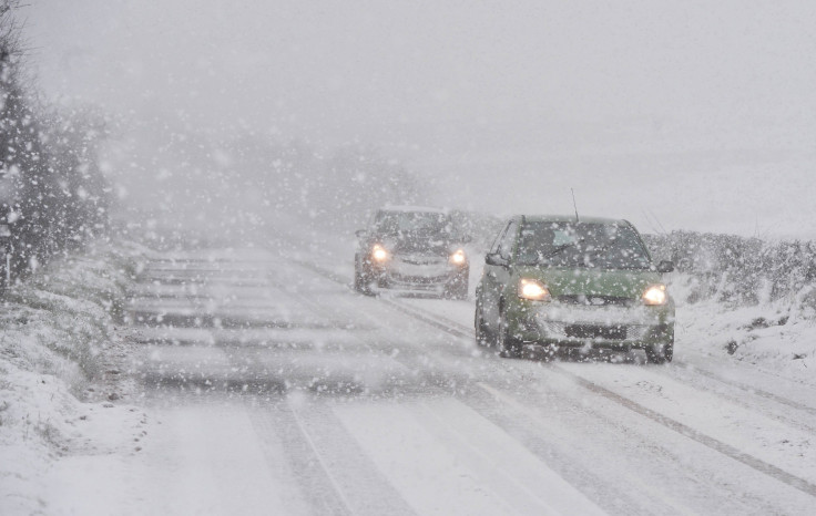
Stormy weather with damaging winds has been forecasted in the western U.S. for the next several days, which has resulted in high wind warnings and winter alerts in affected states, including Oregon, California and Nevada.
"A period of increasingly stormy weather is forecast for the western U.S.," with "very strong winds" expected through Tuesday, the National Weather Service (NWS) said in its Short Range Public Discussion report published Sunday.
By Tuesday, a few inches of rainfall is possible on the West Coast and into central California. Officials warned of a potential threat of flash flooding and urged residents to monitor weather alerts.
The NWS in Portland, Oregon said many parts of the state will see rainfall through Monday, with Mount St. Helens possibly seeing up to three inches with a mix of snow.
We're in a rainfall lull for a few more hours, but the next wave comes in after 4 pm this afternoon. Here are the 24 hour precipitation totals, the majority of this will be rain, unless you are at Mt St Helens or Mt Hood where the peaks will see snow. 1/3 #ORwx #WAwx pic.twitter.com/ore9txGwNP
— NWS Portland (@NWSPortland) December 25, 2022
The office further noted that residents should expect ice accumulations of a "half inch to an inch." Power outages are also possible.
Expect ice accumulations of a half inch to an inch. Power outages and tree limbs breaking could occur as well. 2/2. #orwx
— NWS Portland (@NWSPortland) December 25, 2022
Significant icing is expected on Oregon roads as freezing rain falls through Monday, resulting in "hazardous" commute conditions. Strong winds could damage trees in affected areas, the office added.
In California, officials at the NWS in Sacramento said strong south to southwest winds with snowfall would result in difficult mountain travel conditions from Tuesday morning through Wednesday morning.
Strong south to southwest winds and snowfall will create difficult mountain travel conditions Tues morning-Wed morning.
— NWS Sacramento (@NWSSacramento) December 25, 2022
Snow levels will start out high but will lower Tuesday afternoon.
Blowing snow and significant reductions in visibilities will be possible.#CAwx pic.twitter.com/2lCEbuBUNa
Up to 24 inches of snow accumulation is possible in areas above 6,000 feet, the office noted. Wind gusts of up to 70 mph are also expected along with widespread blowing snow that could result in "significant" reductions to visibility.
Over in Nevada, the NWS in Reno warned of damaging wind gusts that could reach up to 80 mph in affected areas where High Wind Warnings have been issued.
⚠️HIGH WIND WARNING⚠️ in effect for much of northeast CA and western NV from Monday night - Tuesday eve. Strong and potentially damaging winds are expected with travel, recreation & aviation impacts. Secure outdoor holiday decorations! More at https://t.co/Jziy0IS2ru #cawx #nvwx pic.twitter.com/z7yVdpV0Tg
— NWS Reno (@NWSReno) December 25, 2022
In the Sierra Ridges, specifically, wind gusts of more than 120 mph are possible, officials warned.
Alerts in Oregon
Ice Storm Warning effective through 10 p.m. Monday:
- Eastern Columbia River Gorge of Oregon
Ice Storm Warning effective through 4 a.m. Tuesday:
- Central Columbia River Gorge and Upper Hood River Valley (ice accumulations of one-half to one inch possible)
High Wind Warning effective from 7 p.m. Monday through 10 a.m. Tuesday:
- Curry County Coast and South Central Oregon Coast (wind gusts of up to 70 mph possible)
High Wind Warning effective from 7 p.m. Monday through 10 p.m. Tuesday:
- Siskiyou Mountains, Southern Oregon Cascades, South Central Oregon Cascades (wind gusts of up to 80 mph possible)
High Wind Warning effective from 10 p.m. Monday through 10 a.m. Wednesday:
- Central and Eastern Lake County
- Northern and Eastern Klamath County
- Western Lake County
Alerts in California
High Wind Warning effective through 4 a.m. Tuesday:
- Coastal del Norte, Del Norte Interior, Northern and Southern Humboldt Interior, Southwestern Humboldt (wind gusts of up to 75 mph possible)
High Wind Warning effective through 4 p.m. Tuesday:
- Central Siskiyou County
High Wind Warnings effective through 10 a.m. Tuesday:
- West Slope Northern Sierra Nevada, Western Plumas County, Lassen Park (wind gusts of up to 85 mph possible)
- Lassen-Eastern Sierra and Plumas-Eastern Sierra (wind gusts of up to 70 mph possible)
- Greater Lake Tahoe Area (wind gusts as high as 130 mph possible and waves of up to 6 feet on Lake Tahoe possible)
- Mono County (wind gusts near 100 mph possible)
- Surprise Valley California (wind gusts of up to 70 mph possible)
Flood Watches effective through 7 a.m. Tuesday:
- North Bay Interior Mountains, North Bay Interior Valleys, Sonoma Coastal Range
- Santa Cruz Mountains, Santa Lucia Mountains, Los Padres National Forest
Flood Watches effective through 9 a.m. Tuesday:
- Northern Monterey Bay, San Francisco, San Francisco Peninsula Coast
- Coastal North Bay, including Point Reyes National Seashore
- Southern Monterey Bay, Big Sur Coast
Alerts in Nevada
High Wind Warnings effective from 10 p.m. Monday through 10 p.m. Tuesday:
- Mineral and Southern Lyon (wind gusts of up to 70 mph possible)
- Greater Reno-Carson City-Minden Area (wind gusts of up to 80 mph)
- Northern Washoe County
Winter Storm Watch effective from Tuesday morning through 10 a.m. Wednesday:
- Greater Lake Tahoe Area in Nevada (up to 24 inches of snow accumulations possible above 7,000 feet, wind gusts of up to 100 mph in the Sierra ridgetops possible)
© Copyright IBTimes 2025. All rights reserved.
- MOST POPULAR IN National


