

Google Maps Update Shows Devastation Of Russian Invasion On Ukraine: Bombed Buildings, Mass Graves

KEY POINTS
- The images showed hundreds to thousands of buildings razed following Russian shellings
- The satellite image included the city's theater where up to 600 Ukrainian civilians were killed
- The images also showed previously unknown evidence of mass burial sites in the city
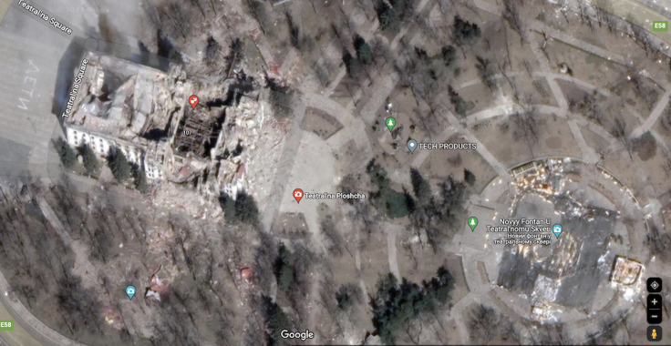
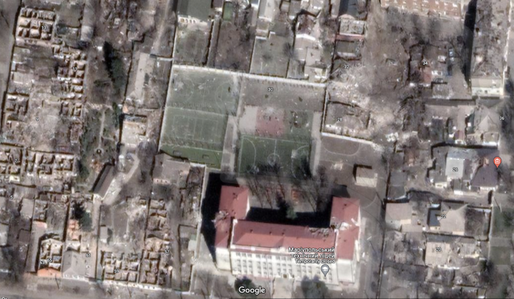
Google Maps updated satellite imagery of the temporarily occupied Ukrainian city of Mariupol, revealing rows upon rows of razed buildings and mass graves.
The images showed hundreds to thousands of buildings hollowed out by shelling from the Russian army. Many of the buildings were shown to have been blackened by the bombings or reduced to rubble, including the Donetsk Academic Regional Drama Theater where up to 600 civilians were believed to have died following a Russian air strike on March 16 last year, as per an Associated Press investigation.
The map also showed evidence of previously unknown mass burial sites, particularly in the Vynohradne and Manhush areas, according to Petro Andryushchenko, an advisor to the mayor of Mariupol.
"The [grave sites] are visually larger in size than the mass graves in Vynohradne or Manhush. The Novotroitske cemetery was closed and under the control of the occupiers for a long enough time (approximately until mid-July)," he wrote in a post on Telegram.
Andryushchenko noted that it is unclear when the mass graves were dug up and who is buried in them but vowed that they would work out the "whole truth" after Russian forces are pushed out of the region.
"We do not reduce the activity of monitoring and obtaining information about Russian crimes in Mariupol for even a minute until the last criminal of the occupiers is punished," he added.
Despite the recent update, Google Maps still made the street view pictures of what the city looked like before Russia launched its full-scale invasion of Ukraine available alongside the new photos. Maxim Eristavi, the co-founder of the independent news platform Hromadske International, posted images of Mariupol's before and after on his Twitter feed.
"I am in a very dark wormhole ... staring at the devastation and clicking on pins of places that used to be, instead of today's ruins," he wrote in the caption.
Mariupol was one of the first cities Russia attacked when it invaded Ukraine in February 2022. What followed after was a three-month siege that saw the city come under intense shelling. The city surrendered in May 2022 and remains under Russian occupation.
© Copyright IBTimes 2025. All rights reserved.
- MOST POPULAR IN World


