Have you ever wondered about apps that could save your life and save your from boredom? Here's the list of the top 10 life-saving apps.
Two tropical storms, one hurricane going through Atlantic Ocean, Gulf of Mexico.
As Hurricane Katia's path moves away from the U.S.,Tropical Storm Maria is cranking up with good odds of becoming a hurricane and eventually striking the U.S., forecasters say. Already, the storm's short-term forecast path takes Maria much father south than Katia, meaning an eventual northern turn lands close to or on the U.S. East Coast.
Tropical Storm Maria developed in the central Atlantic on Wednesday as Hurricane Katia churned up the sea along the East Coast.
Tropical Storm Maria has formed in the Atlantic, becoming the 13th named system of the 2011 season. The storm isn't likely to increase to explosive strength, but it could possibly threaten the U.S. East Coast, forecasters say.
The U.S. has likely escaped Hurricane Katia's path but in this busy Atlantic Hurricane Season 2011 current models show the East Coast is at much higher risk from at least two more developing systems through mid-September.The next two names on the list of tropical cyclones are Maria and Nate, and each is potentially developing already and models show each has a shot at impacting the U.S.
After strengthening into a major Category 4 storm on Monday, Hurricane Katia has since downgraded a level on Tuesday as it moves northwest of the Caribbean. While there isn't any immediate threat to land, dangerous rip currents still remain the main hazard along the U.S. East Coast and Bermuda, forecasters say.
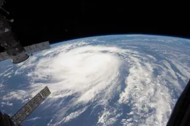
While forecasters suggest that the path of Hurricane Katia 2011 may only graze the U.S. East Coast, one weather scenario suggests a more severe impact. A Category 3 storm with winds of 125 miles per hour, Katia is moving steadily northwest in the Atlantic at 10 miles per hour, still far from land and not posing an immediate threat.
Hurricane Katia on Monday night strengthened into a major Category 4 storm, the second highest level as it moved over the Atlantic Ocean, the National Hurricane Center said.
Katia strengthened to a Category 4 hurricane Monday night but is unlikely to hit the U.S. East Coast, the National Hurricane Center said.
Hurricane Katia 2011 is growing stronger, and while the storm's path still leaves unaswered questions some along the U.S. East Coast from Florida to the Carolinas could feel its impact before it's all over with late next week.
Hurricane Katia is a Category 2 storm with winds of 105 miles per hour, and further strengthening is expected in the next two days, but models show Katia's path may take it out to sea without a direct strike on the U.S. East Coast.
New Jersey is not usually the face of natural disasters. But it became just that on Sunday, when President Obama visited the state to survey the damage caused by Hurricane Irene.
Hurricane Katia strengthened rapidly on Sunday, becoming a Category 2 storm, the U.S. National Hurricane Center said, and forecasters expect it will be a Category 3 storm by Monday.Also, the likelihood that Katia's path will reach the U.S. East Coast is increasing in odds as the storm moves further west.
Hurricane Katia strengthened rapidly on Sunday, becoming a Category 2 storm, the U.S. National Hurricane Center said. Katia had sustained winds of 100 miles per hour, and forecasters said Katia could become a major hurricane on Monday. The exact future track of Katia remains uncertain but models show the U.S. East Coast, and even New York, could bear the brunt of the storm before it's over.
The forecast Hurricane Katia path still leaves unanswered questions that hopefully will be answered by early next week with a positive result, but sharpened models already show New York and the U.S. East Coast could bear the brunt of the storm before it's done.
Tropical Storm Lee stalls off the coast and drenches New Orleans while Hurricane Katia is still a mystery.
Slow-moving Tropical Storm Lee is spawning tornado warnings, evacuation and knocking out power in New Orleans and southern Louisiana on Saturday. Lee has strengthened and continues pounding New Orleans and the Gulf Coast region with heavy rain and flooding threat. The storm has spawned multiple tornadoes and flash flooding in the New Orleans area Saturday, and residents in the town of Jean Lafitte, La. living south of Goose Bayou Bridge have been issued an evacuation order because of possible fl...
Hurricane Katia is maintaining strength and direction on Friday, and while a direct strike on the U.S. is not highly likely at this time, the storm could still take a path similar to what Hurricane Earl did last year, with impact along the East Coast without making landfall late next week. Also, a U.S. strike remains a possibility since storm forecast models so far in advance high a high margin of error. Meanwhile, Tropical Storm Lee is drenching the U.S. Gulf Coast, with the worst yet to come. ...
Tropical Storm Lee will pound the Gulf Coast today and into the weekend, putting levees in New Orleans that breached during Katrina at risk before eventually spreading heaving rains and flooding risks from the coastal region up through the Appalachians. One forecaster said Lee could become a billion dollar coastal disaster for the U.S. coastal region.
Workers active at 169 production platforms and 16 drilling rigs have been evacuated till now and the shutting-in procedures have been activated at all the production platforms.
The U.S. is on high tropical cyclone alert, as Tropical Storm Lee strengthens and is forecast to inundate the Gulf Coast including New Orleans with possible severe flash flooding and Hurricane Katia forces U.S. East Coast residents to keep a keen on that storm's strengthening and path.