

NASA Satellite 1 Million Miles Away Spots Typhoon Bavi

KEY POINTS
- Typhoon Bavi made its way to the Korean Peninsula this week
- An NOAA-NASA satellite 1 million miles away captured an image of the typhoon
- The image shows a full-disk view of the Earth
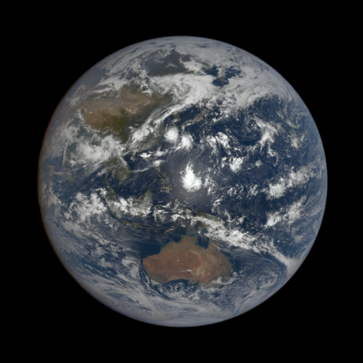
A full satellite image of the Earth shows Typhoon Bavi as it was moving through the Yellow Sea. The satellite that captured it is in orbit in the L1 zone, which is about one million miles away from the Earth.
The eighth tropical storm of the 2020 Pacific typhoon season, Typhoon Bavi, moved from Taiwan's east coast toward the Korean Peninsula this week. In an image captured by the NOAA-NASA Suomi NPP satellite on Aug. 25 and shared by NASA Earth Observatory, the typhoon can be seen as it was making its way toward the Korean Peninsula.
On the same day, another satellite much farther away, the NOAA-NASA DSCOVR satellite, also captured an image of Typhoon Bavi. Compared to the Suomi NPP satellite, which is in a polar orbit around the Earth at an altitude of about 512 miles, the DSCOVR satellite is one million miles away from the Earth. So the image that it captured actually shows a full-disk view of the planet.
In the image, captured by the Earth Polychromatic Imaging Camera (EPIC) aboard DSCOVR and shared by NASA, one can see a full-disk view of the Earth with Typhoon Bavi in the Yellow Sea.
DSCOVR's main mission from its L1 orbit between the Earth and the sun is actually to provide real-time solar wind monitoring. At the L1 orbit, it is in an excellent position to monitor the sun because the constant stream of particles from the sun reaches L1 an hour before it reaches the Earth. This way, DSCOVR can provide ample warning before a potential geomagnetic storm reaches the Earth.
This is an important task because geomagnetic storms can potentially disrupt major public infrastructure systems including the power grid, aviation, communications and GPS.
At this orbit, EPIC also has a constant view of the Earth and can also provide valuable scientific observations of the Earth, including the ozone, cloud height, aerosols, and vegetation. It can also provide unique views of the Earth.
Typhoon Bavi unleashed powerful winds and heavy rain on the southern island of Jeju on Wednesday and is expected to make landfall in North Korea early on Thursday. But, the storm is said to have already reached its peak intensity and could begin to weaken.
© Copyright IBTimes 2025. All rights reserved.
- MOST POPULAR IN Science


