

NASA Satellite Image Shows Fire Scars On Australia's Kangaroo Island

KEY POINTS
- NASA satellites are often the first to detect wildfires in remote regions
- Before and after images of Kangaroo Island show the island's burn scars
- Ecologists estimate that 25,000 koalas have died from the fires
Just how extensive are the fire damages to Australia’s Kangaroo island? Before and after images from NASA’s Terra satellite show the island’s burn scars.
Satellite Images
Various NASA satellites have been monitoring the devastating fires in Australia, and the agency just released before and after images of Kangaroo Island captured by the Terra satellite using the Moderate Resolution Imaging Spectroradiometer (MODIS) instrument.
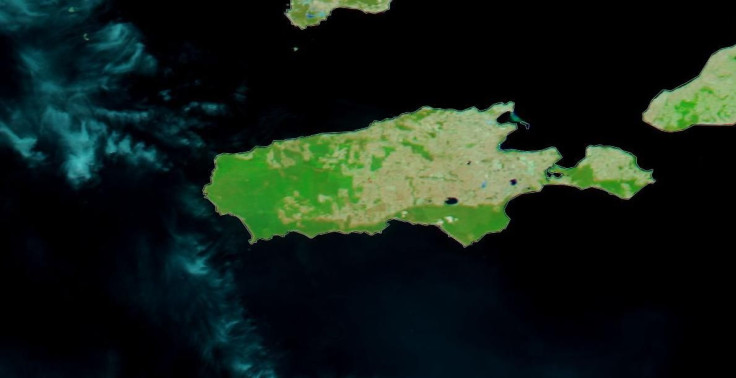
The before image of Kangaroo Island was taken last Dec. 16, 2019, while the second image was taken Jan. 7, 2020 when the fires have already ravaged a substantial part of the island.
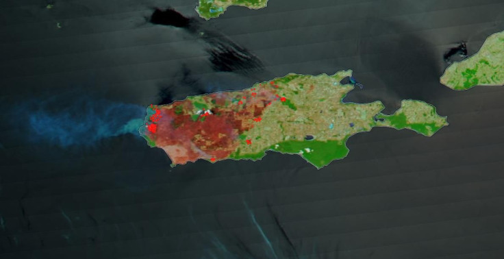
In the after image, one can see the devastation on the island, with a third of the landmass clearly showing burn scars as well as some parts that are still on fire.
According to NASA, the bushfires at Kangaroo Island began as lightning strikes at Flinders Chase National Park. Since the fires began, ecologists estimate that about 25,000 koalas have died, or about half of the koala population on the island.
Kangaroo Island
A third of Kangaroo Island is comprised of protected nature reserves that are home to wildlife such as koalas, sea lions and various endangered bird species that have bounced back from the brink of extinction in the past decades.
The popular tourist destination is the third-largest island after Tasmania and Melville Island, and it boasts the world’s only disease-free and pure-bred population of Ligurian honey bees. Often called a “zoo without fences,” Kangaroo Island offered protection to wild animal populations for many years.
Unfortunately, the “ecological tragedy” has so far ravaged 383,013 acres of the island, with some of its iconic landscapes previously covered by greenery now hosting burned trees.
In late 2007, parts of Kangaroo Island were also left with burn scars due to wildfires that persisted for days.
NASA Satellites
Often, NASA satellite instruments are the first to detect wildfires in remote regions, and images of the suspected fires are quickly sent to land managers within hours to help firefighters manage the situation on-site.
“Together, NASA instruments detect actively burning fires, track the transport of smoke from fires, provide information for fire management, and map the extent of changes to ecosystems, based on the extent and severity of burn scars,” NASA states.
© Copyright IBTimes 2025. All rights reserved.
- MOST POPULAR IN Science


