

NASA Shares Satellite Images Of Historic Flooding In Michigan

KEY POINTS
- The Landsat 8 satellite captured images of the historic Michigan flooding
- The heavy rainfall had caused two dams in the area to fail
- By May 20, the flood levels were already higher than Michigan's 1986 "Great Flood"
NASA Earth Observatory shared on Friday satellite images of the historic flooding in Michigan, showing the extent of the damage in the affected communities. Several structures and roads were flooded and over 10,000 residents had to be evacuated.
A stalled low pressure system and frontal boundary across the southern Great Lakes region resulted in heavy rains pouring over the Tri-Cities area of central Michigan from the morning of May 17 till May 19. The record rain caused flooding in several rivers, eventually resulting in the collapse of the Edenville dam. Water then spilled over the Sanford dam about an hour later, further worsening the flooding in nearby communities.
As a result, Michigan Gov. Gretchen Whitmer declared a state of emergency for Midland County and urged its residents to immediately evacuate.
"This is a truly historic event that’s playing out in the midst of another historic event," Whitmer said at a press conference.
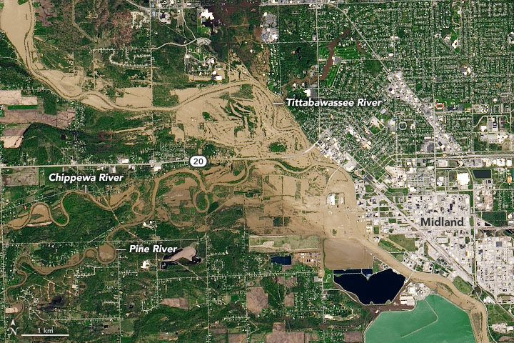
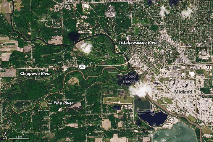
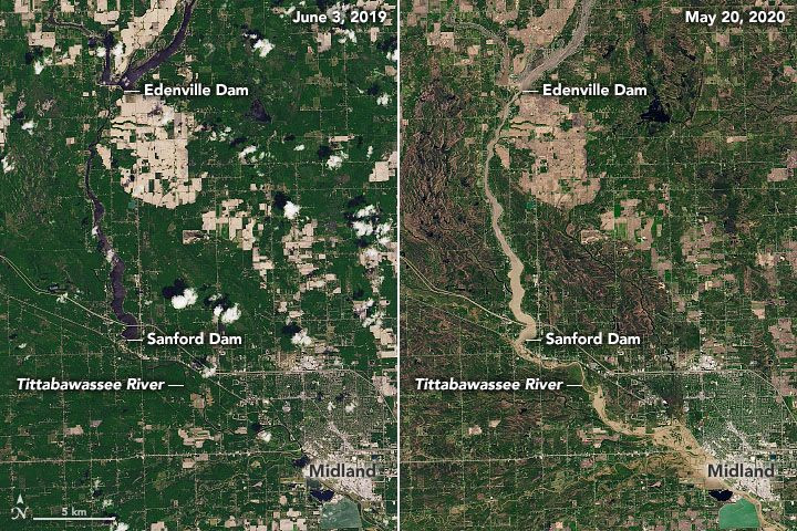
Natural-color images from NASA and the United states Geological Survey's Landsat 8 satellite showed the extent of the massive flooding. The first image showed Tittabawassee River from June 3, 2019, without the flooding while another image showed the same area May 20, 2020 when rivers were already swelled and nearby communities were flooded.
A side-by-side image provides a wider view of the area from the same dates, this time including the Sanford and Edenville dams.
"While a stalled low pressure system bringing soaking rainfall often occurs at least once or twice during the spring months in the vicinity of southeast Michigan, the combination of heavy rainfall, significant lakeshore and river flooding, and the resultant dam failures in Midland county make this event historically significant," the National Weather Service said.
According to NASA Earth Observatory, on May 20, the Tittabawassee River reached a height of 35 feet (11 meters), which is over 16 feet above the flood stage. These levels are also higher than those during Michigan's "great flood" of Sept. 12, 1986, considered one of the greatest natural disasters in the state's history.
Back then, the floods caused 10 deaths and cost over $505 million in damages, which equates to about $1 billion in damages by today's standards.
© Copyright IBTimes 2025. All rights reserved.
- MOST POPULAR IN Science


