

NASA Satellite Images Show Controversial Dam Flooding 12,000-Year-Old Town In Turkey

KEY POINTS
- The town of Hasankeyf has been occupied by various cultures for 12,000 years
- Hasankeyf will be submerged in water because of the new Ilisu Dam
- The construction of Ilisu Dam was controversial
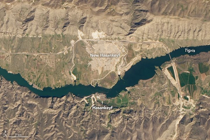
Data provided by the Operational Land Imager on the Landsat 8 satellite show the changes that happened to an ancient town because of the new Ilisu Dam in Turkey. The natural-color images taken in in 2019 and in 2020 show how different the landscape has become and how close Hasankeyf is to being submerged.
In the February 2019 image, there was only a small amount of water around Hasankeyf but, by the the time the second image was taken March 12, 2020, a significant part of Hasankeyf was already flooded.
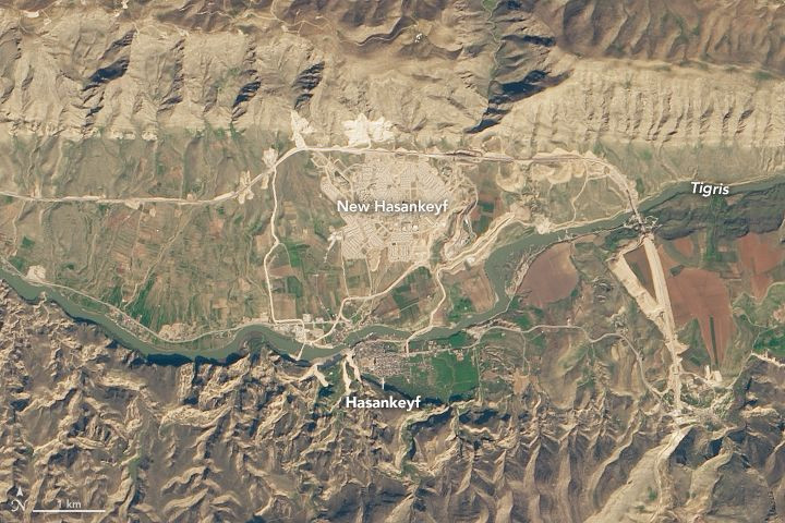
According to NASA, by February 2020, the water level behind the dam was rising at a rate of about 15 centimeters, or 6 inches, per day. Interestingly, the dam is so far just about a quarter full, which means that the water may still rise 50 more meters in the coming months. As It does, the historical structures and artifacts in Hasankeyf could be nearly completely submerged.
As for the residents of Hasankeyf, they were given until October of 2019 to evacuate and were relocated to a nearby hill called New Hasankeyf. Once the reservoir becomes full, a ferry would bring them to and from the old and new Hasankeyf.
12,000-Year-Old Town
Hasankeyf is one of the oldest continuously inhabited settlements in the world, with evidence that the town has been settled in by 20 cultures starting from 12,000 years ago. This makes Hasankeyf a town that is rich in history and artifacts that have been preserved for thousands of years -- from tombs, ancients baths, mosques and Assyrian-carved caves.
However, this rich history may soon be submerged because of the controversial Ilisu dam, which was still built despite objections from both local and international groups. As one of Turkey's largest hydroelectric projects, Ilisu dam is expected to generate 1,200 megawatts of electricity, providing about 1.5 percent of the country’s electricity needs.
The project is a key part of Turkey’s Anatolia project to improve its least developed and poorest region. Unfortunately, it also displaces over 80,000 people, affects 199 settlements along the Tigris River and decreases the water supply in Syria and Iraq.
Although the residents in the affected towns were relocated to "new" towns and some of the historical artifacts were moved to other parts of Turkey, the images taken by Landsat 8 are testaments to the price that people have to pay for energy independence and economic growth.
© Copyright IBTimes 2025. All rights reserved.
- MOST POPULAR IN Science


