

NOAA-NASA Satellite Image Shows Flooded Rivers In Mississippi, Louisiana

KEY POINTS
- Persistent rains have caused rivers to swell from Missouri to the Gulf of Mexico
- A satellite image shows major rivers spreading onto their floodplains
- Mississippi Gov. Tate Reeves described the flooding as 'historic' and 'unprecedented'
- The Pearl River flooding from Feb. 17 became the third highest level for Jackson
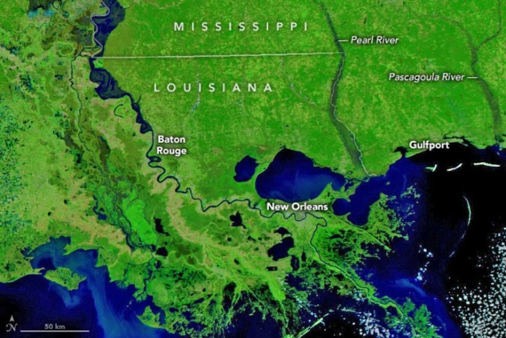
Mississippi has faced historic floods in the first two months of 2020. A new image from NOAA and NASA’s Visible Infrared Imaging Radiometer Suite (VIIRS) satellite, show the flooding along the rivers in the region, particularly the Mississippi, Pearl and Pascagoula rivers.
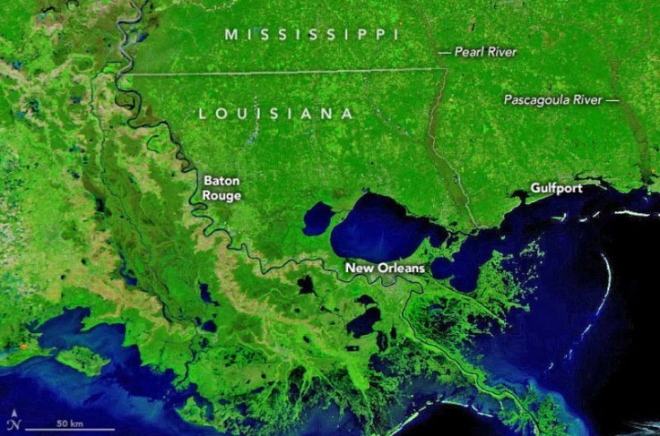
Compared to a satellite image taken March 3, 2017, which shows the rivers’ normal conditions, the image taken on Feb. 27, 2020, shows the rivers spilling out of their banks and onto their floodplains.
By the time that the Feb. 27 image was taken, the flooding had subsided from its highest stage in the days prior.
According to the NASA Earth Observatory, the thick clouds that covered the area for 10 days prevented the satellite from getting a clear view of the flooding at its most severe stage. That said, the image from Feb. 27 used a combination of visible and near-infrared light to make the parts of the rivers that are flooded more visible.
'Historic,' 'Unprecedented' Flooding
Due to the persistent heavy rains, a large portion of the southern U.S. experienced near-record flooding, particularly in parts of Mississippi and Tennessee. Perhaps the hardest hit in the region was Jackson where hundreds of residents fled their homes when the Pearl River rose up to 36.8 feet (11.2 meters) on Feb. 17.
At the peak of the flooding, Mississippi Gov. Tate Reeves described the flooding as "historic" and "unprecedented." In fact, the flood level reached on Feb. 17 became the third highest level on record for the city after April 1979 and May 1983. It is now also the highest level on record since 1983.
By Feb. 29, the Pearl River had already dropped from major to moderate flooding at 17.86 feet (5.44 meters) but at least 17 river gauges were still above the flood stage along the Mississippi River while five more were flooded along the Pearl River.
Unfortunately, weather experts say this could be the beginning of a disastrous flooding year, particularly in central United States. In 2019, flooding in the Missouri, Arkansas and Mississippi River basins caused 12 deaths and about $20 billion in damages.
© Copyright IBTimes 2025. All rights reserved.
- MOST POPULAR IN Science


