

Super Typhoon Mawar Path: 2023's Most Intense Storm Heads Toward Philippines
KEY POINTS
- Mawar has "slightly intensified while moving westwards over the Philippines sea"
- The center of the storm was approximately 195 miles northwest of Guam on Thursday
- It is now expected to hit the northern part of Luzon and Taiwan
Super Typhoon Marwar has become 2023's most intense storm, and is reportedly heading toward the Philippines.
Earlier this week, the typhoon--which is now strengthening into a powerful Category 5 hurricane--battered Guam, before moving away from the Mariana Islands.
The state weather agency of the Philippines, PAGASA, said Mawar has "slightly intensified while moving westwards over the Philippines sea." According to reports, the typhoon will move toward Taiwan as well, bringing heavy rains to the region, apart from hitting the northern part of Luzon in the Philippines.
The path of Marwar originated about 537 miles south of Guam, later moving westwards. The center of the storm was approximately 195 miles northwest of Guam around 8 p.m. local time Thursday, The New York Times reported.
Heavy rain, landslides, gale-force winds and floodings are expected in Luzon from late Sunday or Monday.
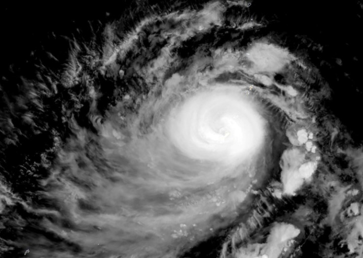
"Typhoon Mawar was one of the strongest in decades to lash the U.S. territory of Guam," NASA Earth wrote on Facebook, sharing satellite images of Marwar. "The NOAA-20 satellite acquired this image at 1:50 p.m. local time (03:50 Universal Time) on May 24, 2023, as Mawar approached Guam. At the time, the storm carried sustained winds of about 140 miles (225 kilometers) per hour—equivalent to a category 4 storm on the Saffir-Simpson wind scale."
"The image shows the typhoon's cloud bands completely covering the islands, which were already being lashed with powerful winds and heavy rain. (The bright area in the top-left of the image is sunglint—an optical phenomenon unrelated to the storm.)"
The Philippine president, Ferdinand Marcos Jr, said on Facebook that authorities in the country are preparing in case the typhoon makes landfall.
"We continue to focus on Super Typhoon Mawar which is expected to enter the Philippine Area of Responsibility (PAR) tomorrow night or Saturday morning. We are also preparing for its impact not only in the northern part of the country, but in all areas that may be affected by the typhoon," the statement read [Google Translate showed].
"There is a possibility that the typhoon will pull the southwest wind that will bring heavy rain and result in flooding in some parts of the country from Luzon to Visayas," he said, adding: "In the meeting with DND Sec. Carlito Galvez, we made sure that the fund and food packs are pre-positioned, the response teams are on standby, and the LGUs are ready in the areas that will be hit by the typhoon."
Meanwhile, Jim Yang, a researcher at the China Meteorological Association, said there was a high chance Typhoon Mawar would make landfall in China.
"If it lands in Fujian, it will become the first typhoon in history to land in Fujian in May," Jim Yang wrote on Twitter. He also attached a photo of the predicted strike probability.
"If Mawar finally lands in Taiwan, it will become the first typhoon to land in Taiwan in May in 33 years," he said.
As Typhoon Mawar's peak winds surged to 175 mph, accompanied by gusts nearing 210 mph, the Joint Typhoon Warning Center announced that it has become the most intense storm of 2023, making it equivalent to a category 5 super typhoon, which it will remain for two more days, before weakening.
© Copyright IBTimes 2024. All rights reserved.
- MOST POPULAR IN World


