NASA Maps Antarctic Ice Flow (PHOTO and ANIMATION)
For the first time, NASA researchers have mapped the speed and direction of ice flow in Antarctica.
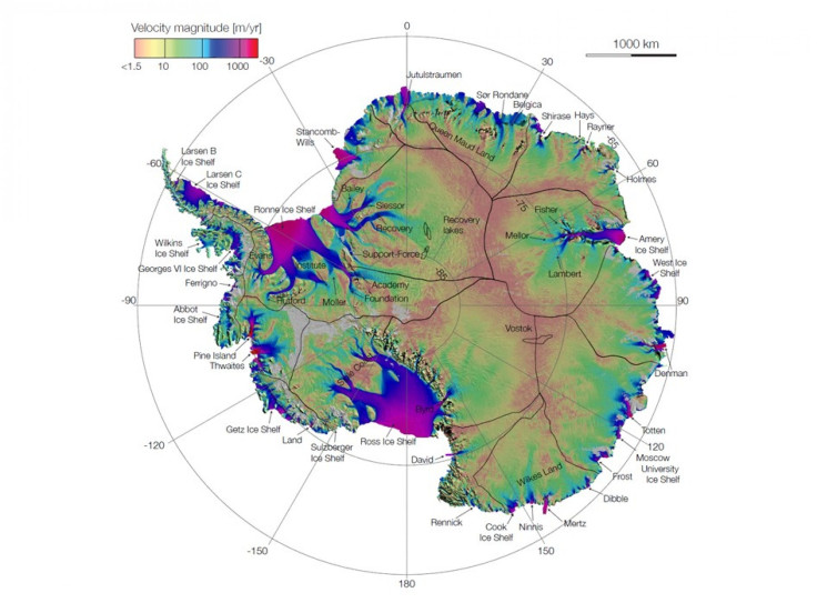
The researchers from NASA's Jet Propulsion Laboratory (JPL) in Pasadena, Calif., and the University of California (UC) used billions of data points from American, European, Japanese and Canadian satellites to map the ice flow. Leading the research was Eric Rignot, a professor at Earth System Science School of Physical Sciences at UC. Rignot is also the principal scientist at the Radar Science and Engineering Section at JPL.
The satellite data accumulated by Rignot and his team points allowed the researchers to get rid of cloud cover, solar glare and land features that mask the glaciers. This technology allowed them to piece together the shape and velocity of glacial formations and create the map like it was a jigsaw puzzle.
When they completed the map, they were taken aback at a discovery they made. The researchers discovered a new ridge splitting the 5.4 million-square-mile (14 million-square-kilometer) landmass from east to west. They also found unnamed formations moving up to 800 feet, which move annually across large plains to the Antarctic Ocean.
The map points out something fundamentally new: that ice moves by slipping along the ground it rests. That's critical knowledge for predicting future sea level rise. It means that if we lose ice at the coasts from the warming ocean, we open the tap to massive amounts of ice in the interior, said Thomas Wagner, NASA's cryospheric program scientist in Washington.
The researchers say the data can help track future sea-level increases from climate change.
This is like seeing a map of all the oceans' currents for the first time. It's a game changer for glaciology, Rignot said. We are seeing amazing flows from the heart of the continent that had never been described before.
A paper describing the work Rignot and his crew did was published in a recent issue of Science Express. Rignot, NASA and the team of researchers relied on data from overseas satellites to accumulate the data. According to Yves Crevier of the Canadian Space Agency, it was the first time a large amount of civilian space agencies collaborated to create a huge data set.
It is a dataset of lasting scientific value in assessing the extent and rate of change in polar regions, Crevier said.
Here is an animation of the movement.
Follow Gabriel Perna on Twitter at @GabrielSPerna
© Copyright IBTimes 2026. All rights reserved.
- MOST POPULAR IN Science