

Nepal Earthquake: The 'Nightmare' Everyone Saw Coming

On April 12, less than two weeks before Saturday's devastating earthquake laid waste to wide swathes of Nepal's landscape, a team of experts had gathered in Kathmandu to assess Nepal’s level of preparation for a major earthquake, and sounded an alarm about the country's lack of preparation for such an event. This was not the first time such a warning had been issued.
On Jan. 15, 1934, an 8.2-magnitude earthquake struck Nepal, killing over 10,600 people and causing widespread damage across the country. Thousands were also killed in the Indian state of Bihar, making the earthquake one of the deadliest natural disasters in the region’s history. In 1998, more than 60 years after the disaster, a joint report by Nepal’s National Society for Earthquake Technology and GeoHazards International, a U.S.-based nonprofit, warned that a quake of the same magnitude could kill as many as 40,000 people.
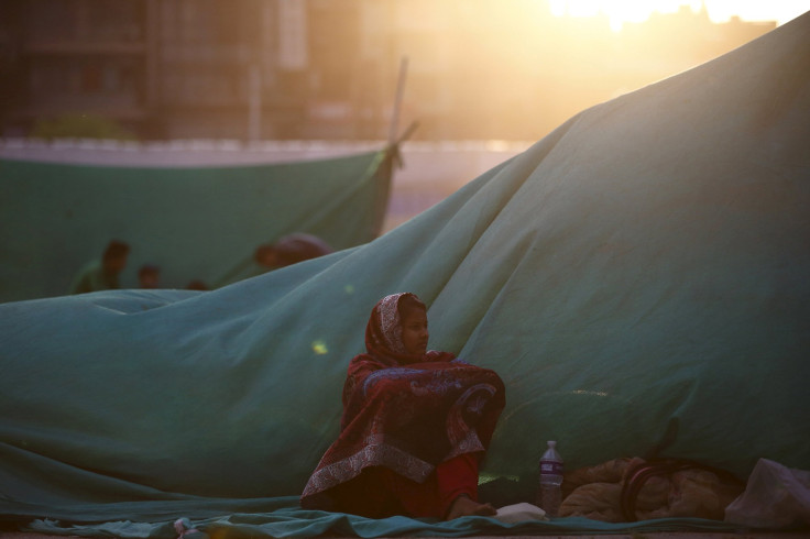
Saturday's 7.8-magnitude quake came nearly 17 years after this report was released. And while the deaths caused by the latest earthquake are so far substantially lower than predicted -- currently standing at just over 3,200 -- the two disasters, separated by a span of over 80 years, highlight Nepal’s vulnerability to earthquakes.
“It was sort of a nightmare waiting to happen,” seismologist James Jackson, head of the earth sciences department at the University of Cambridge in England, reportedly said. “Physically and geologically what happened is exactly what we thought would happen.”
Nepal sits along a major plate boundary. On Saturday, the India plate, which has been moving northward since the Indian subcontinent collided with the Eurasia plate 40 million to 50 million years ago, leading to the creation of the Himalayas, shifted to thrust below the Eurasia plate. This movement released a shockwave that moved upward toward the Kathmandu Valley.
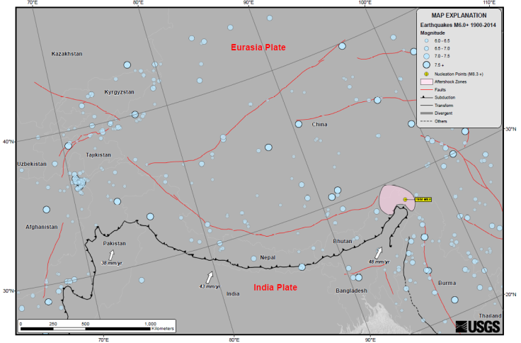
“Northward underthrusting of India beneath Eurasia generates numerous earthquakes and consequently makes this area one of the most seismically hazardous regions on Earth,” the U.S. Geological Survey (USGS) said, in a statement. “Examples of significant earthquakes, in this densely populated region, caused by reverse slip movement include the 1934 M8.0 Bihar, the 1905 M7.5 Kangra and the 2005 M7.6 Kashmir earthquakes.”
Taken together, these three events killed over 100,000 people. While Nepal’s vulnerability can be blamed on natural seismic faults, several manmade factors, including unplanned urbanization and blatant disregard of building codes, are believed to be responsible for the widespread damage.
Following the meeting on April 12, a report summarizing the risks faced by the Kathmandu valley said that people living in the region “were clearly facing a serious and growing earthquake risk" as construction around the densely-populated Kathmandu Valley did not account for seismic activity, and that local government agencies did not have access to proper technical knowledge about earthquake risks.
"They knew they had a problem but it was so large they didn't (know) where to start, how to start," Hari Kumar, southeast Asia regional coordinator for GeoHazards, told AP.
© Copyright IBTimes 2025. All rights reserved.
- MOST POPULAR IN Science


