

Arizona Bighorn Fire: NASA Satellite Captures Photo Of Damage From Space

KEY POINTS
- NASA shared a satellite image of Arizona's Bighorn Fire from space
- The image showed the massive damage the fire inflicted
- Arizona has been battling several major bush fires in the last month
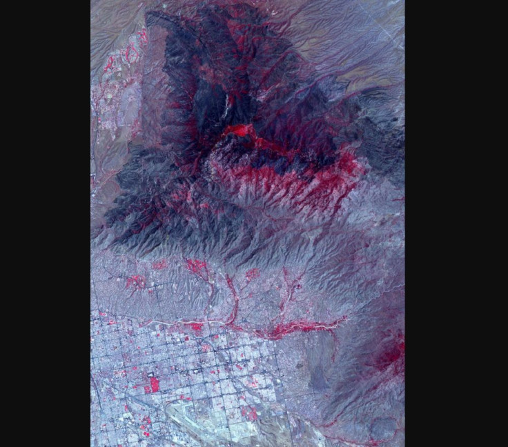
A NASA satellite image showed the major damage inflicted by the Bighorn Fire north of Tucson, Arizona. As of Wednesday (July 1), the fire has burned over 118,000 acres of land.
It was in the evening of June 5 when a lightning strike started the Bighorn Fire in the Santa Catalina Mountains and quickly spread with the help of strong winds and "extremely dry vegetation."
On June 29, weeks after the fire started, the Advanced Spaceborne Thermal Emission and Reflection Radiometer (ASTER) instrument aboard NASA’s Terra satellite captured an image of the area seriously affected by the Bighorn Fire.
In the image shared by NASA, the red indicated vegetation while the dark gray areas were parts that have been burned. In the lower part of the image, one can see how close Bighorn Fire is to communities.
According to InciWeb, the multi-agency incident information system, as of Wednesday, Bighorn has affected 118,370 acres, making it the second largest fire burning in the United States and one of the largest wildfires in Arizona history.
About 1,000 firefighters are still working on extinguishing it, which, as of Wednesday, has been 54% contained. Hand crews, 10 helicopters and dozens of fire engines have also been deployed to help contain the fire.
Although many homes were evacuated because of Bighorn, no houses were lost and many people were allowed to finally return home.
Bighorn is not the only fire Arizona has been battling in the past month. The region has been damaged by the Mangum Fire, the Bush Fire and the Bringham Fire also.
As of Wednesday, the Bush Fire, which quickly became one of the largest wildfires in Arizona history, had burned 193,455 acres in Tonto National Forest and was at 98% containment. Meanwhile, Bringham Fire has burned 23,142 acres and was 40% contained, and the Mangum Fire has burned over 71,000 acres north of the Grand Canyon and was 67% contained.
Recently, two new fires popped up in Arizona: The Avondale fire that started June 26 and has already been completely contained, and the Wood Springs 2 Fire, which has burned close to 9,000 acres with 0% containment.
Although wildfire season in Arizona generally ends with the monsoon, slow moisture arrival this year along with abundant fuels will keep the danger above normal well into the month. Please be careful out there. We've had way too many big fires so far. #azwx https://t.co/fQSBXtUZqY
— NWS Phoenix (@NWSPhoenix) July 1, 2020
© Copyright IBTimes 2025. All rights reserved.
- MOST POPULAR IN Science


