

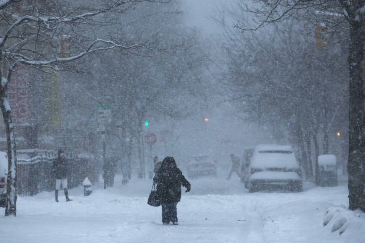
Central US Braces For Major Storm; Up To 25 Inches Of Snow Possible

KEY POINTS
- Up to 25 inches of snow accumulations is possible in some parts of South Dakota
- Wind gusts of up to 65 mph is possible in parts of Colorado
- Extreme winter storm conditions are expected in parts of Wyoming
A major winter storm is expected to bring extreme weather conditions to the central United States through Thursday. Blizzard Warnings have been issued in six states as officials projected the possibility of up to 25 inches of snow accumulations in several affected states, including South Dakota.
"Major storm system to bring significant, widespread weather hazards from severe weather to blizzard conditions to the central U.S.," the National Weather Service (NWS) said in its Short Range Public Discussion report published Monday.
"The highest snow totals are currently forecast for western South Dakota and northwestern Nebraska, where upwards of 18-24 inches is possible," the NWS noted.
In Nebraska, officials at the NWS in North Platte are expecting blizzard conditions with heavy snow and thunderstorms.
Snow will develop across northwest Nebraska this evening and become heavy at times with falling temperatures and winds gusting to 35 mph. Blizzard conditions are likely. Showers and thunderstorms across southwest Nebraska will move north and expand in coverage tonight. #NEwx pic.twitter.com/nahbxrEv2g
— NWS North Platte (@NWSNorthPlatte) December 13, 2022
Over in South Dakota, officials at the NWS in Sioux Falls said a mix of rain, freezing rain, sleet and snow is possible through Tuesday morning.
Various types of precipitation will fall across the area this evening through Tuesday morning.
— NWS Sioux Falls (@NWSSiouxFalls) December 12, 2022
Here's a look at the probability of the type that should occur during the majority of the period.
If temperatures overnight cool slightly more, icy conditions will expand southwest. pic.twitter.com/p02q2f56dL
The NWS in Rapid City also noted that blizzard conditions are expected through "much" of Tuesday and Tuesday evening.
Key points for early tomorrow AM:
— NWS Rapid City (@NWSRapidCity) December 13, 2022
- If you wake up with only an inch or two of snow, this doesn't mean you're out of the woods!
- A glaze of ice due to tonight's freezing drizzle will be present under the snow in many locations, leading to difficult or hazardous travel conditions pic.twitter.com/6pWHqRU0KQ
In Colorado, the NWS in Boulder said the heaviest snow totals are expected in mountainous areas and the northeast plains. Up to 10 inches is possible in Byers, up to 11 inches is possible in Wiggins, Fort Morgan and Sterling, while up to 12 inches is possible in Last Chance.
Here are the latest highway snowfall graphics for the winter storm tonight through Wednesday. ❄ Heaviest totals will fall across the mountains and northeast plains. Blizzard conditions from Wiggins to Julesburg. Avoid travel there!⚠⛔ #cowx pic.twitter.com/a24WixZrlg
— NWS Boulder (@NWSBoulder) December 12, 2022
Kansas will experience numerous showers and thunderstorms through Tuesday morning, the NWS in Wichita said. Up to 60 mph winds are possible, along with dime-sized hail.
Numerous showers and thunderstorms will race northeast across the region tonight through early Tuesday morning. A few of the storms may become strong to marginally severe, with dime size hail and 50 to 60 mph winds. #kswx pic.twitter.com/WdjX59B2OZ
— NWS Wichita (@NWSWichita) December 12, 2022
In Wyoming, officials at the NWS in Cheyenne are expecting extreme winter storm conditions in Lusk and Chadron from Tuesday morning through noon.
PM Update: Winter Storm Timelines
— NWS Cheyenne (@NWSCheyenne) December 13, 2022
Here's a look at expected weather impact timelines for the next 48 hours. Impacts could continue after falling snow comes to an end due to strong winds and blowing snow.#wywx #newx pic.twitter.com/itNKnawI4n
In Montana, forecasters are expecting up to 16 inches of snow accumulations through Thursday morning in several areas such as the Bighorn Canyon, Southern and Northern Big Horn and Treasure.
The NWS in Billings also warned of "major impacts," such as hazardous travel conditions in the following areas: Broadus, Buffalo, Bowman, Sheridan, parts of Miles City, and Gillette.
Expect hazardous travel conditions across portions of the area through late Wednesday night. The greatest impacts will be across north-central Wyoming and southeast Montana. Here are some tips on what you can do to prepare and stay up to date on the latest information #mtwx #wywx pic.twitter.com/eA0GtQk1ym
— NWS Billings (@NWSBillings) December 12, 2022
Officials have issued Blizzard Warnings and several other winter alerts in six states.
Winter alerts in Nebraska
Blizzard Warning effective through 11 p.m. Tuesday:
- Dundy (wind gusts of up to 65 mph possible)
Blizzard Warning effective through 11 p.m. Wednesday:
- Dawes – Northern Sioux, Banner, Box Butte, Cheyenne, Dawes, Kimball, Morrill, Scotts Bluff, South Sioux ((wind gusts of up to 60 mph possible)
Blizzard Warnings effective through 6 a.m. Thursday:
- Sheridan – Cherry, Garden, Hooker, Arthur and Deuel (up to 20 inches possible)
- Brown – Keya Paha, Thomas, Keith and McPherson (wind gusts of up to 50 mph possible)
Winter alerts in South Dakota
Blizzard Warnings effective through 5 a.m. Thursday:
- Rosebud Reservation – Bennett, Haakon, Jackson, Mellette, Todd and Tribal Lands of the Pine Ridge Reservation (up to 25 inches possible)
- Northern Meade Co Plains – Butte, Harding, Perkins and Ziebach (up to 20 inches possible)
- Fall River – Oglala Lakota and Southern Foot Hills (up to 24 inches possible)
- Custer Co Plains – Pennington Co Plains, Southern Meade Co Plains, Sturgis/Piedmont Foot Hills (up to 20 inches possible)
- Northern Foot Hills (up to 24 inches possible)
Ice Storm Warnings effective through 11 a.m. Tuesday:
- Kingsbury – Lake and Minnehaha (wind gusts of up to 40 mph possible)
- Parts of east central South Dakota – Brookings and Moody (wind gusts of up to 40 mph possible)
Ice Storm Warning effective through 5 p.m. Tuesday:
- Parts of northeast South Dakota – Clark, Codington, Day, Deuel, Grant, Hamlin, Marshall and Roberts (wind gusts of up to 45 mph possible)
Winter alerts in Colorado
Blizzard Warnings effective through 11 p.m. Tuesday:
- Central and East Adams – Logan, Morgan, Briggsdale, Byers, Sterling, Akron, Northeast Weld and Washington (wind gusts of up to 60 mph possible)
- North Lincoln – North and Northeast Elbert (wind gusts of up to 50 mph possible)
- Philips and Sedgwick (wind gusts of up to 60 mph possible)
- Kit Carson and Yuma (wind gusts of up to 65 mph possible)
Winter alerts in Kansas
Blizzard Warning effective through 11 p.m. Tuesday:
- Cheyenne (wind gusts of up to 65 mph possible)
High Wind Warning effective through 6 p.m. Wednesday:
- Greeley – Cheyenne, Sherman and Wallace (power outages due to high winds possible)
Winter alerts in Wyoming
Blizzard Warning effective through 5 p.m. Wednesday:
- Northeast Johnson County (wind gusts of up to 45 mph possible)
Blizzard Warnings effective through 11 p.m. Wednesday:
- Central Laramie – South Laramie Range Foothills (wind gusts of up to 55 mph possible)
- Converse County Lower Elevations – East Laramie, East Platte, Goshen, Niobrara, North Snowy Range Foothills (wind gusts of up to 60 mph possible)
Blizzard Warnings effective through 5 a.m. Thursday:
- Sheridan Foothills (up to 16 inches possible)
- Northern and Southern Campbell – Western Crook (up to 18 inches possible)
- Northeastern Crook (up to 20 inches possible)
- Wyoming Black Hills (up to 24 inches possible)
Winter alert in Montana
Blizzard Warning effective through 5 a.m. Thursday:
- Carter and Powder River (up to 16 inches possible)
© Copyright IBTimes 2025. All rights reserved.
- MOST POPULAR IN National


