El Nino Update 2014: El Niño Odds Drop To 65% This Fall As Pacific Ocean Conditions Weaken, US Scientists Say

U.S. forecasters say the odds of an El Niño appearing this year have dropped to 65 percent, down from the 80 percent estimated last month. The event will also be weaker than first expected if it does appear in the fall or early winter.
Even so, “we’re still fairly confident that El Niño will come,” Michelle L’Heureux, a meteorologist with the National Oceanic and Atmospheric Administration, told Climate Central. NOAA’s Climate Prediction Center released its monthly update on Thursday. Forecasters say an El Niño will probably emerge between August and October and peak at weak strength in the months that follow.
El Niño’s final outcome could determine how cold and nasty the winter gets in parts of the central and eastern United States. Since late last year, a dip in the Northern Hemisphere’s jet stream has been pushing chilly Arctic air to the south, resulting in lower-than-normal temperatures from the east of the Rockies to the Atlantic Coast.
An El Niño event could “bump us out of this persistent jet-stream pattern,” Jeff Masters of Weather Underground told International Business Times earlier this week. “If it doesn’t happen, then maybe we’re stuck here.”
During an El Niño event, warm water that typically pools in the eastern Pacific starts to slosh its way toward the Americas, propelled by westerly winds and shifting ocean currents. The commotion helps to raise the overall sea-surface temperatures in the Pacific, which in turn heats up the atmosphere, creating what scientists call a “mini” global warming event and potentially disrupting the jet stream.
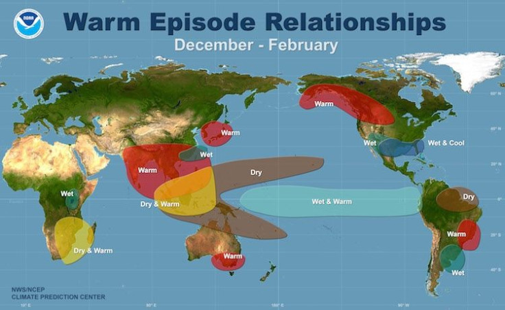
The phenomenon also impacts rainfall, since rain-carrying clouds follow the warm waters on their westward journey, bringing heavy rains and flooding to South America and California and leaving a trail of drought in Australia and Asia. But NOAA’s latest projections indicate that drought-stricken California won’t see much relief from an El Niño. Southern California could see above-average rainfall, but the state needs a massive scale of precipitation to break from its crippling three-year drought.
Federal scientists say they reduced their El Niño estimates in part because the above-average sea-surface temperatures observed in June have since shrunk to a thin layer of warmth, under which lie below-average ocean temperatures. Warmer waters are needed to fuel a stronger El Niño event, as well as to warm up the atmosphere. So far, the atmosphere hasn’t responded strongly to the changes in the Pacific.
El Niño now has a 2-in-3 chance of occurring, instead of the 4-in-5 chance that was initially projected, accorded to the update.
© Copyright IBTimes 2026. All rights reserved.
- MOST POPULAR IN Business