

Great Barrier Reef Goes Online With Google Help [PHOTOS & VIDEO]

Soon armchair travelers will be able to scuba dive the Great Barrier Reef from the comfort of a home computer thanks to a pioneering research survey that will map out the world's largest coral reef system for an online audience.
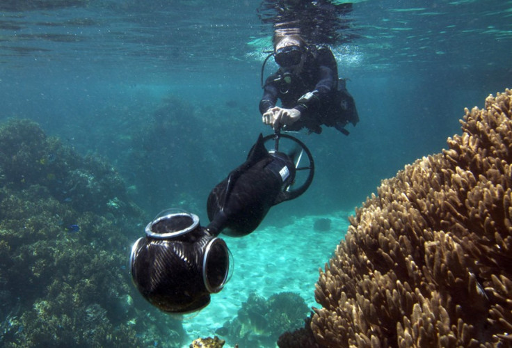
By photographing and mapping out the landscape with a pair of unmanned submarine cameras, the project will allow virtual divers to experience rarely seen coral reefs, underwater grasslands, and craggy drop-offs teeming with marine life.
The survey will use the high-tech underwater cameras up to a depth of 100 meters, or about 328 feet, to carry out the most comprehensive study of the reef to date - and the public is encouraged to follow each step of the process on Google sites.
Chief scientist Ove Hoegh-Guldberg of the Global Change Institute at the University of Queensland will head the Catlin Seaview Survey, which starts in September.
During the launch of the survey at the World Ocean Summit in Singapore Thursday, Hoegh-Guldberg stressed that the visual nature of the project would also help bridge the gap between scientific knowledge and public awareness.
The Catlin Seaview Survey comprises a series of studies which will reveal to the public one of the last frontiers of Earth: the oceans, he said. For the first time in history, we have the technology available to broadcast the findings and expedition through Google. Millions of people will be able to experience the life, the science, and the magic that exists under the surface of our oceans.
This project is very exciting, he noted, adding, he hoped to capture the public's imagination and engage people with science by making it a daily activity.
The collaboration between global insurance company Catlin Group Ltd., not-for-profit organization Underwater Earth (the project creators), and Google seeks to help form a global audience to assess the health and composition of the 1,430-mile-long (2,300km) reef off Queensland state.
Google is working on a new feature on Panoramio, which links photos to locations, so that the 360-degree panorama images can be uploaded and made available to a global audience.
Eventually, roughly 50,000 panoramas from the survey will be accessible on Google Earth and Google Maps in addition to a dedicated YouTube channel for hangouts where people can watch livestreams of the expedition team from the ocean floor.
Hoegh-Guldberg said the project would strengthen the understanding about how climate change and other environmental changes are likely to affect ocean ecosystems like the Great Barrier Reef.
Fishing and tourism along the reef earns Australia about $6 billion a year, he said, but scientists are still trying to figure out how rising sea temperatures and increased ocean acidity will affect the region over the long term.
The Catlin Seaview Survey camera will take tens of thousands of 360-degree, high-definition panoramas which, when stitched together, will open up this natural wonder to the world.
The survey will be three-pronged: a shallow reef survey; a deep reef survey; and a mega-fauna survey, which combined will provide a baseline assessment of the biodiversity, composition, and well-being of the Great Barrier Reef.
Other findings are expected on sea temperatures, calcification rates, reef bleaching, and whether deep coral can provide the spores needed to rebuild damaged coral closer to the surface.
Scientists will also tag manta rays, green turtles, and tiger sharks to be tracked online by satellite to learn about migration patterns.
In the future, the project creators hope to expand the survey globally to reveal the oceans in regions of importance across the map.
There are some images available online from a six-day pilot mission where scientists said they found a new species of pygmy seahorse and four types of coral that had never been seen in the region.
Countless more discoveries are likely as an estimated 93 percent of the reef remains unexplored.
According to Hoegh-Guldberg, it's like going to the Amazon in 1800.
© Copyright IBTimes 2025. All rights reserved.
- MOST POPULAR IN Technology


