How NASA Helps Fight Wildfires

KEY POINTS
- NASA satellites are often the first to detect wildfires
- Data from the instruments help inform agencies fighting the fires
- NASA instruments also capture how fires affect environment
NASA is not only a space agency that explores the cosmos but it also keeps track of the things that are happening on Earth. Here's how NASA is helping with the fight against wildfires, including the major ones currently ongoing in California.
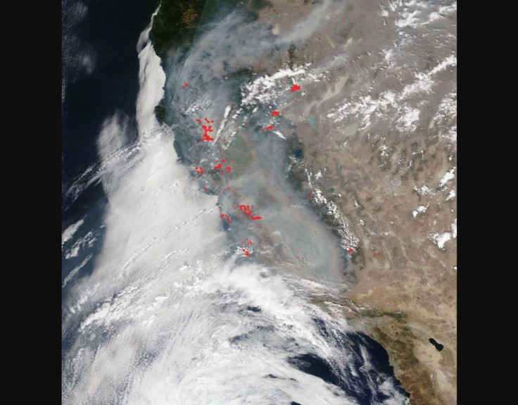
NASA's instruments are often the first ones to detect wildfires, especially when it comes to the remote regions where people might not immediately detect the fires. This is because the agency has multiple satellites and instruments that help with fire management including ones that can detect actively burning fires, the transport of the smoke from the fires and even the changes in the ecosystem as a result of the fires.
In the ongoing California wildfires, considered to be one of the worst wildfire seasons on record, NASA has been providing the agencies on the ground with vital information.
"When disasters like this occur, we are able to swiftly respond to requests from our partners who need images and mapping data," manager of the Disasters Program at NASA Headquarters, David Green, said in a NASA feature. "Likewise, in the aftermath of the fires, our researchers will use orbital and aerial data of the burn areas to help mitigate hazards such as landslides and mudslides."
Instruments that can help with the effort include the ones aboard the Aqua, Terra and CALIPSO satellites, with the data being passed to NASA partners so that they can track the fires and their impact. Polar-orbiting satellites such as the Terra and Aqua can even provide detailed views of the fires up to twice a day.
Throughout the California wildfires, NASA has been providing data and satellite imagery vital to fighting the fires and the other issues that may arise from it. For example, data on the movement of smoke from California to the rest of the country helped inform local public health officials whose areas could be affected by the potentially hazardous wildfire smoke even if they seem so far away from the actual fires.
NASA also has the Uninhabited Aerial Vehicle Synthetic Aperture Radar attached to an aircraft that will fly over several counties and known fires to accurately measure the changes in the ground. Although the instrument is primarily used to study ground elevation, it is also effective at mapping burn scars.
Such a feat is important because burn scars not only measure the sheer amount of damage a wildfire has inflicted on an area, but they also bring problems of their own, including the possibility of flash floods and mudslides due to the ground not being able to absorb as much water as it used to.
"We will also fly our short wavelength infrared imager looking in the same direction as UAVSAR, which will see the fire through the smoke," principal research scientist at JPL, Andrea Donnellan, said. "These combined data can help us better understand how these active fires are affecting the area."
Together, these and many other NASA instruments provide a unique view of the wildfires, helping in the efforts to mitigate them and providing a better understanding of how they affect the environment.

© Copyright IBTimes 2026. All rights reserved.
- MOST POPULAR IN Science