

NASA Satellite Image Shows The Mississippi River Flooding

KEY POINTS
- The Mississippi River area has been experiencing persistent heavy rains
- NASA satellite images show the river water spilled out from its banks
- The region is also recovering from the record flooding in 2019
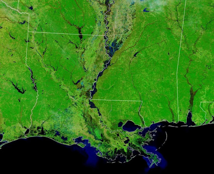
Images taken by the Moderate Resolution Imaging Spectroradiometer (MODIS) instrument on NASA’s Terra satellite show the effect of the persistent rains in the Mississippi Delta.
After the winter flooding, the region is also preparing for the 2020 spring flood season.
Mississippi River Flooding
False-color images of the Mississippi River captured by NASA’s Terra satellite show the marked difference in the river from Dec. 4, 2019 to Feb. 2, 2020. Compared to the December photo when the river looks relatively normal, the February 2020 image clearly shows that the water has swelled and spilled over the banks and onto floodplains.
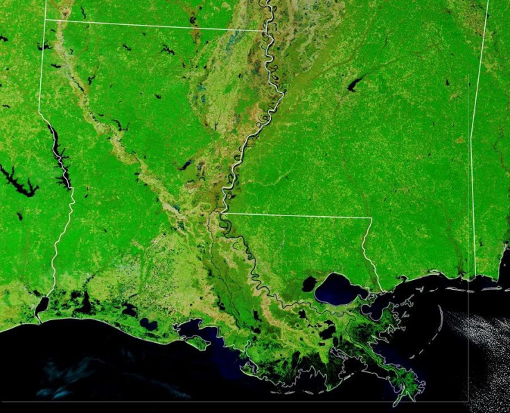
By the time of the second photo, the river was already near or above flood stage in parts of Tennessee, Arkansas, Lousiana and Mississippi, although the water had already reached the highest expected point in most places and is expected to begin to decrease some time soon.
That said, as of the morning of Feb. 4, the National Oceanic and Atmospheric Administration still reported flooding in some areas while the National Weather Service (NWS) was still issuing flood warnings. According to NWS, the soil in the Upper Mississippi watershed is nearly already saturated, which is why its capacity to absorb new rainfall is already compromised.
Flood Season
The river’s swelling, according to NASA, is caused by the persistent heavy rains experienced across the Mississippi watershed. The area has been seeing a lot of water in the past decade and, in fact, at this same time in 2019, the river was still not showing signs of falling and the Mississippi River remained at or above the flood stage from January until early August.
The flooding has been rather problematic for people in the area, particularly for commercial shrimp and oyster operations that get disrupted by lengthened periods of high, muddy and cold waters. Commercial and recreational fishing as well as hunting in the area are also suffering as a result of the floods, while some significant construction projects in New Orleans had to be halted as well.
For now, the region is still recovering from the floods, but it is also preparing for the coming 2020 spring flood season. The hope is that is will not be as persistent as 2019’s when the first six months of the year were logged among the wettest January-through-June periods on record and, several places logged the year’s flooding as the longest Mississippi River flood on record.
© Copyright IBTimes 2025. All rights reserved.
- MOST POPULAR IN Science


