

NASA, USGS Satellite Image Shows California Mineral Fire From Space

KEY POINTS
- California's Mineral Fire has burned over 28,000 acres of land
- A satellite image of the fire shows burn scars, thick smoke and fire retardant marks
- The cause of the fire remains unknown and under investigation
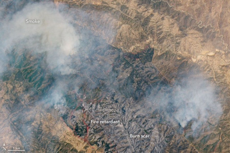
A NASA-United States Geological Survey satellite captured the image of the ongoing Mineral Fire in California. The fire started on July 13.
Over 1,500 personnel have been battling the Mineral Fire that has been burning in Fresno County for several days. In a natural-color image captured by the Landsat 8 satellite on July 17 and shared by NASA Earth Observatory, thick smoke can be seen emanating from the affected area while burn scars are evident in the lower part of the image. Close to the burn scars, there are red streaks that are likely marks of the fire retardant that authorities dropped in the area to stop the fire from spreading further.
Similar red marks were also observed in satellite images of the recent Bush Fire in Arizona, which quickly became one of the largest wildfires in the state's history.
The Mineral Fire, which started in fields west of the city of Coalinga, has already burned 28,221 acres of land and remains active. It has since destroyed seven structures and threatens 60 more.
The fire is already 49% contained and, California authorities expect containment by July 23. Evacuation orders for areas in Fresno and Monterey counties have also been lifted, including the orders for the roadways that were closed. However, those who will pass by the area are still being advised to "proceed with caution" as firefighters will remain working to contain the fire.
The exact cause of the Mineral Fire remains unknown and it is still under investigation.
07/20/2020 #MineralFire Morning update. pic.twitter.com/bEnSnDvGoK
— CALFIRE/FresnoCoFire (@FresnoCoFire) July 20, 2020
As for the necessary precautions against COVID-19, authorities assure that they are adhering to the federal guidelines.
"Incident personnel continue to adhere to state and federal recommendations regarding COVID-19, including wearing a mask, social distancing, and sanitizing work stations," California Department of Fire Protection said.
Following the federal guidelines are important in maintaining firefighters' safety and well being amid the pandemic. Only recently, the U.S. Navy confirmed that several USS San Diego sailors who fought the USS Bonhomme Richard fire tested positive for COVID-19 after some sailors reported the scene at the fire to be "chaotic," with some of them having to swap and share firefighting equipment, including gloves and masks.
© Copyright IBTimes 2025. All rights reserved.
- MOST POPULAR IN Science


