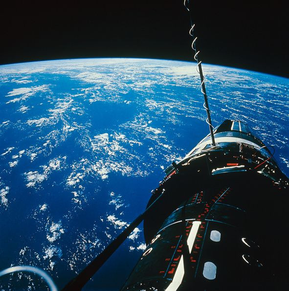
#PictureEarth: NASA Shares Amazing Earth Day Photos

NASA recently commemorated Earth Day 2019 by sharing incredible and amazing photos of the Earth from satellites, aircraft and deep-space missions.
As we celebrate #EarthDay, enjoy these views of our home that can only be seen from the distance of deep space. In conjunction with our #Apollo50th anniversary, we’re sharing thoughts from our @NASA_Astronauts who’ve beheld the beauty of Earth from afar: https://t.co/P5HIAf4TyJ pic.twitter.com/dVlzftmB45
— NASA (@NASA) April 22, 2019
"Everyday, we have a fleet of @NASAEarth spacecraft orbiting our home planet that is always collecting data to help us better understand our dynamic world." a Twitter post from NASA read.
Happy #EarthDay! Everyday, we have a fleet of @NASAEarth spacecraft orbiting our home planet that are always collecting data to help us better understand our dynamic world. See how we study our home planet: https://t.co/aaqqWIb0Bj pic.twitter.com/ot3NCf14h4
— NASA (@NASA) April 22, 2019
NASA space probes are orbiting the planet and gathering satellite imagery data to help us better understand our ever-changing planet. This Earth Day 2019, NASA invited us to celebrate the planet we call home through a social media event called #PictureEarth.
There may be no better view of Earth than from the International Space Station. In honor of #EarthDay, enjoy these photos taken by @NASA_Astronauts from 250 miles above our home planet. You can search astronaut photography here: https://t.co/QU0gAlONAb. #PictureEarth pic.twitter.com/NtEPQzbYyj
— International Space Station (@Space_Station) April 22, 2019
NASA called everyone to post a close-up photo on social media of their favorite natural features of the Earth, such as crashing waves, ancient trees, blooming flowers, or stunning sunsets.
Our magnificent planet is ready for its close-up 📸, & on #EarthDay, April 22, we’re calling on YOU! Help us celebrate by uploading a photo of your favorite natural features using #PictureEarth. Learn how your pictures could be featured in future projects: https://t.co/gDOQtg6iDs pic.twitter.com/xwlYMqqBqu
— NASA (@NASA) April 21, 2019
Netizens have responded to NASA's invitation and posted some of their favorite photos in the hashtag #PictureEarth.
"Barrancas del Cobre, Chihuahua, México. #PictureEarth #EarthDay," Gaby Parra wrote on a Twitter post.
"#pictureearth Valley of Fire state park," another Twitter user shared.
#pictureearth Valley of Fire state park pic.twitter.com/9jEsjU2VwJ
— Cheshin (@Homefry13) April 23, 2019
"Picture taken in south tyrol italy #PictureEarth #EarthDay," @Horizonlss wrote in a Twitter post.
Picture taken in south tyrol italy #PictureEarth #EarthDay pic.twitter.com/Ionw3oOouX
— ISS Horizons (@HorizonsIss) April 23, 2019
NASA also joined #PictureEarth by sharing some of its most stunning images of Earth captured from satellite, airborne instruments that broaden our knowledge about our home planet and improve lives.
Currents swirl like watercolors. Sediment layers like oil paint. Landforms sculpt from erosion like clay. Our @NASAEarth satellites capture awe-inspiring images of Earth on a daily basis to help us learn about our home planet. Get inspired for #EarthDay: https://t.co/Fc893FbEse pic.twitter.com/QyrHmkVFCq
— NASA (@NASA) April 22, 2019
"The outlet glacier of Vavilov Ice Cap has gone from sliding 20 meters per year to 20 meters per day. What triggered this dramatic surge is still unknown, but w/ our @NASAEarth satellites data we now have a time-lapse of the damage," a Twitter post from NASA said.
Satellite imagery of NASA enables us to have a clear view of what is happening on our planet and provide bases for our future actions.
The outlet glacier of Vavilov Ice Cap has gone from sliding 20 meters per year to 20 meters per day. What triggered this dramatic surge is still unknown, but w/ our @NASAEarth satellites data we now have a time-lapse of the damage. Dive into the situation: https://t.co/rAfFr9QAWW pic.twitter.com/czf5ku6Cmz
— NASA (@NASA) April 21, 2019
These images, shared by scientists and the public worldwide, may use visible light, like a photographer's camera, or peer into infrared, microwave and radio wavelengths that are invisible to human eyes.
.@NASAEarth satellite views & data visualizations help us understand the Earth and how it’s changing. This #EarthDay, we invite you to share how you #PictureEarth too. Share photos of your favorite natural features w/ the location & hashtag #PictureEarth: https://t.co/Xl2RI69ysQ pic.twitter.com/r9gXDLjBlH
— NASA (@NASA) April 22, 2019
Scientists use data from all of NASA's instruments and Earth-observing spacecraft from other nations to build a picture of the planet that grows more and more complete over time.
Of all the planets we have explored, none have matched the dynamic complexity of our own. Join us at 3pm ET for #NASAScience Live, where experts discuss what makes our planet so special for #EarthDay. Ask questions during the program using #askNASA: https://t.co/2YssUynRAc pic.twitter.com/Cj6ffwfs6N
— NASA (@NASA) April 22, 2019
To check out more of the stunning images posted by NASA this Earth Day 2019, visit Earth Day Image Gallery: Celebrating Earth's Beauty.
© Copyright IBTimes 2025. All rights reserved.


