

Thick Smoke From Intense Summer Fires In Siberia Seen From Space

KEY POINTS
- Satellites captured the thick smoke emanating from the intense fires in Siberia
- Strong winds occasionally carry the smoke to other regions, including Alaska
- The fires have led to record carbon emissions
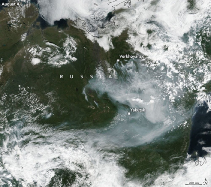
Satellites captured the massive smoke plumes coming from Siberia amid the intense fire season the region has been experiencing.
NASA Earth Observatory shared a timelapse of the smoke billowing from the Sakha Republic, one of the most active fire regions in Siberia this summer. In the timelapse, captured by the Visible Infrared Imaging Radiometer Suite (VIIRS) instrument on NASA and the National Oceanic and Atmospheric administration's (NOAA) Suomi NPP satellite and NASA's Terra satellite, one can see the massive smoke plume emanating from the region spreading to other, nearby regions.
According to NASA Earth Observatory, strong winds even occasionally brought the smoke plumes as far as Alaska in late July.
Satellite footage shared by the Cooperative Institute for Research in the Atmosphere (CIRA) on Twitter also shows the thick smoke covering Siberia, as captured in GeoColor by Japan Meteorological Agency's Himawari-8 satellite. In the short clip, the landscape is barely visible due to the thick smoke.
As fires continue in Siberia, extensive smoke blankets the region.
— CIRA (@CIRA_CSU) August 6, 2020
Seen in GeoColor by Himawari-8: https://t.co/yKFcKMxbR2. pic.twitter.com/ZzutXhxq8J
There were about 19 fires burning in the province as of Aug. 6. Siberia was having a difficult time controlling the wildfires amid the record warm weather the region has been experiencing. In July, for instance, there was a point when there were nearly 300 wildfires in Russia's northern wilderness.
"After the Arctic fires in 2019, the activity in 2020 was not so surprising through June," senior scientist at the Copernicus Atmosphere Monitoring Service, Mark Parrington, said. "What has been surprising is the rapid increase in the scale and intensity of the fires through July, largely driven by a large cluster of active fires in the northern Sakha Republic."
Unfortunately, these fires have led to record carbon emissions, with the fires releasing more carbon dioxide in June and July 2020 than any other complete fire season since data collection began in 2003. By mid-June alone, the intensity of the fires released 59 million tons of carbon dioxide – the highest carbon emissions for the month of June.
Part of the problem is that the fire has been burning through areas with peat soil, which is a large source of carbon. After the warm temperatures thawed the peatlands and made them very flammable, the fires led to the release of massive amounts of carbon.
"If fire seasons continue to increase in severity, and possibly in seasonal extent, more peatlands will burn," Dorothy Peteet of NASA's Goddard Institute for Space Studies said. She and her colleagues recently reported that the amount of carbon stored in northern peatlands is actually double the previous estimates. "This source of more carbon dioxide and methane to our atmosphere increases the greenhouse gas problem for us, making the planet even warmer."
Peat fires are said to take longer to burn and some of the regions that are burning have been too difficult to reach because of their remote locations. To fight the fires, Russian authorities have also turned to measures including explosives and cloud seeding.
In the U.S., several states have also been experiencing intense wildfires, one of the more recent ones being California's Apple Fire, which was also captured by satellites. Earlier, NASA satellites also captured images of Arizona's record Bush Fire.
© Copyright IBTimes 2025. All rights reserved.
- MOST POPULAR IN Science


