

Tornado Watch Issued In 3 Southern States Amid 'Particularly Dangerous Situation'

KEY POINTS
- Damaging wind gusts, strong tornadoes and large hail are expected
- A tornado was confirmed in Louisiana on Tuesday evening
- Hail greater than 2 inches in diameter is expected in Arkansas
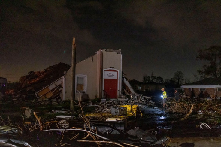
A Tornado Watch is in effect in parts of central Mississippi, northeast Louisiana and extreme southeast Arkansas through early Wednesday as the National Weather Service (NWS) warned that the weather conditions in affected areas present "a particularly dangerous situation" amid severe thunderstorms in the region.
"Scattered supercells will persist through early tonight, with a continued threat for a few strong tornadoes, damaging gusts, and large hail," the NWS said in a Tornado Watch status report released Tuesday evening.
Scattered severe thunderstorms will persist through early tonight, with a continued threat for a few strong tornadoes, damaging gusts, and large hail. ...THIS IS A PARTICULARLY DANGEROUS SITUATION... https://t.co/VyWINDkBnn https://t.co/uYul9GMTk3
— National Weather Service (@NWS) November 30, 2022
"If the environment is favorable, supercell thunderstorms can last for several hours," according to the NWS website.
The NWS further said in its status report that damaging wind gusts of up to 70 mph and "scattered large hail events to 1.5 inches in diameter" is possible in affected areas.
As part of the efforts to urge residents to stay safe and alert for possible changes in weather conditions, the Storm Prediction Center has issued Tornado Watches effective through 2 a.m. Wednesday.
Tornado Watch in Arkansas:
- Ashley, Chicot
Tornado Watch in Louisiana:
- Catahoula, Franklin, Richland, Concordia, Madison, Tensas, East Carroll, Morehouse, West Carroll
Tornado Watch in Mississippi:
- Adams, Carroll, Clay, Grenada, Humphreys, Jefferson Davis, Leake, Lowndes, Neshoba, Oktibbeha, Sharkey, Warren, Winston, Attala, Choctaw, Copiah, Hinds, Issaquena, Kemper, Leflore, Madison, Newton, Rankin, Simpson, Washington, Yazoo, Bolivar, Claiborne, Franklin, Holmes, Jefferson, Lawrence, Lincoln, Montgomery, Noxubee, Scott, Sunflower and Webster
The NWS in Jackson confirmed that a tornado was "on the ground 3 miles NW of Mound, LA" at around 7:30 p.m. Officials urged residents to take shelter and inform authorities of any damage when the coast is clear.
Tornado was confirmed on the ground 3 miles NW of Mound, LA around 7:30 pm. This storm is continuing northeast through the Phoenix and Satartia areas. Take shelter and relay any damage when safe to do so. #lawx #mswx https://t.co/HOKOOzsDhr
— NWS Jackson MS (@NWSJacksonMS) November 30, 2022
At 8:20 p.m., the NWS in New Orleans warned of a storm near Liberty that is "capable of producing a tornado."
8:20 PM - There currently is a storm capable of producing a tornado near Liberty, MS. This storm will move northeast just to the north of Liberty and head into Thompson. If you are in the warning, take cover now! #mswx #lawx pic.twitter.com/gncdC29l2h
— NWS New Orleans (@NWSNewOrleans) November 30, 2022
Earlier Tuesday, the NWS in Little Rock, Arkansas warned that evening storms are forecast to have the potential to produce hail greater than 2 inches in diameter as well as tornadoes and thunderstorm wind gusts of up to 80 mph.
Storms forecast this afternoon and evening across east/southeast AR have potential to produce hail greater than 2", tornadoes, and thunderstorm wind gusts 60-80 mph. Winds at this speed are capable of damage similar to that of smaller tornadoes. #arwx pic.twitter.com/BehKqBuh6i
— NWS Little Rock (@NWSLittleRock) November 29, 2022
The NWS has also released a list of "good options" for people in affected areas to choose from should a tornado hit their locations. The office said basements and interior rooms of "a well-constructed home or building" are great choices.
You know to take shelter immediately if your area receives a Tornado Warning. But what makes a good shelter? Take the time now to figure out your options and make sure you’re #WeatherReady https://t.co/TcEWxVed18 pic.twitter.com/nLvUYNC1ng
— National Weather Service (@NWS) November 29, 2022
The office noted that some of the "best options" for surviving a tornado are taking shelter in a "specifically-designed FEMA (Federal Emergency Management Agency) Safe Room" and "above or below ground" of a Tornado Storm Shelter.
© Copyright IBTimes 2025. All rights reserved.
- MOST POPULAR IN National


