

Winter Storm Warnings: 'Treacherous' Travel Conditions In Utah; Up To 20 Inches Of Snow Possible

KEY POINTS
- Up to 20 inches of snow is possible in the Cottonwoods and Ogden ranges
- Travelers have been asked to exercise extra caution in some areas such as Logan Summit
- Wind gusts of up to 70 mph is possible in the Greater Lake Tahoe area
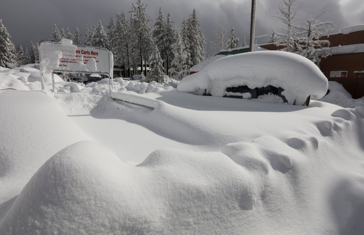
Heavy snowfall continues across Utah and neighboring Nevada, making travel difficult and at times "treacherous" for residents. Up to 20 inches of snow accumulations are possible in some areas by Friday, weather forecasters warn.
"The remaining moisture that is able to progress eastward into the Intermountain West tonight will likely lead to heavy mountain snow into the Utah high elevations. Snow totals of up to 18 inches are possible and will make travel treacherous at times," the National Weather Service (NWS) said Thursday.
Thursday's winter storm can usher in up to 20 inches of snow accumulations in the upper Cottonwoods and Ogden area mountains, and up to 18 inches of snow in the Pine Valleys near Brian Head in Utah, NWS officials added.
Ready for more snow? An incoming winter storm will bring significant mountain snow to the Utah mountains this afternoon through Friday. Here are some of the details on what to expect #utwx pic.twitter.com/T5qS1TUhPY
— NWS Salt Lake City (@NWSSaltLakeCity) January 5, 2023
They are also expecting up to 8 inches of snow in Daniels Summit, up to 10 inches in the Alta area and up 11 inches of snow in Ben Lomond and Tushar Mountains.
As part of its efforts to prevent road accidents, the Utah Department of Transportation (UDOT) published a map highlighting areas where the highest caution should be exercised while driving.
Road Weather Alert:
— UDOT Traffic (@UDOTTRAFFIC) January 4, 2023
Another winter storm will arrive Thu night. Expect winter driving conditions overnight and into Fri for mountain routes, and through Fri morning for valleys.
Valid: 4 PM THU - 8 PM FRI
For more info: https://t.co/4P1gO2c9Uo#utwx #utsnow @UtahTrucking pic.twitter.com/Suxl2Fcyye
"Impaired travel" is expected on State Route 143 Summit, State Route 20 Summit, State Route 153 Summit, Soldier Summit, Provo, Daniels Summit and Logan Summit.
In Nevada, snowfall continued in mountainous terrain Thursday, while rainfall moved through lower elevations, the NWS Las Vegas said.
🌧12:40 PM PST Radar Update: Snowfall continues in the mountains while rainfall moves through lower elevations. Note: radar coverage is not available for Inyo, Nye, and Esmeralda counties. #NVwx #CAwx #AZwx pic.twitter.com/o2KXv0kedN
— NWS Las Vegas (@NWSVegas) January 5, 2023
High avalanche danger is expected in the eastern slopes of the Sierra Nevada Range between Virginia Lakes to the north to Rock Creek to the south, the agency warned. A backcountry avalanche warning has also been issued in these areas.
The Eastern Sierra Avalanche Center has issued a Backcountry Avalanche Warning for the eastern slopes of the Sierra Nevada mountain range between Virginia Lakes to the north to Rock Creek to the south. High avalanche danger will occur through Friday morning. pic.twitter.com/DHIYYhzbXG
— NWS Reno (@NWSReno) January 5, 2023
Alerts in Utah
Winter storm warning effective through 5 a.m. Friday:
- Southern Mountains (up to 18 inches of snow accumulations possible)
Winter storm warning effective through 2 p.m. Friday:
- Wasatch Mountains I-80 North, Western Uinta Mountains, Book Cliffs, Wasatch Mountains South of I-80, Wasatch Plateau and Central Mountains (up to 20 inches of snow accumulations possible)
Winter weather advisory effective through 10 a.m. Friday:
- Wasatch Black, Northern Wasatch Front, Utah Valley, Cache Valley, Eastern Box Elder County, Utah Portion, Rush Valley, Salt Lake Valley and Tooele Valley
Alerts in Nevada
Winter storm warning effective through 10 p.m. Thursday:
- Esmeralda and Central Nye County
Winter storm warnings effective through 4 a.m. Friday:
- Greater Lake Tahoe Area (wind gusts of up to 70 mph possible)
- Spring Mountains – Red Rock Canyon and Sheep Range (up to 15 inches of snow accumulations above 7,000 feet possible)
Winter weather advisory effective through 9 p.m. Thursday:
- White Pine County
Avalanche warning effective through 7 a.m. Friday:
- Central Sierra Nevada Mountains between Yuba Pass on the north and Ebbetts Pass on the south
© Copyright IBTimes 2025. All rights reserved.
- MOST POPULAR IN National


