Center of Tropical Storm Lee to Reach Southern Louisiana This Weekend [MAPS]

Six years after Hurricane Katrina, New Orleans may need to brace for Tropical Storm Lee, which is inching northward up the oil-rich Gulf of Mexico and is expected to creep upon the coast of southern Louisiana this weekend.
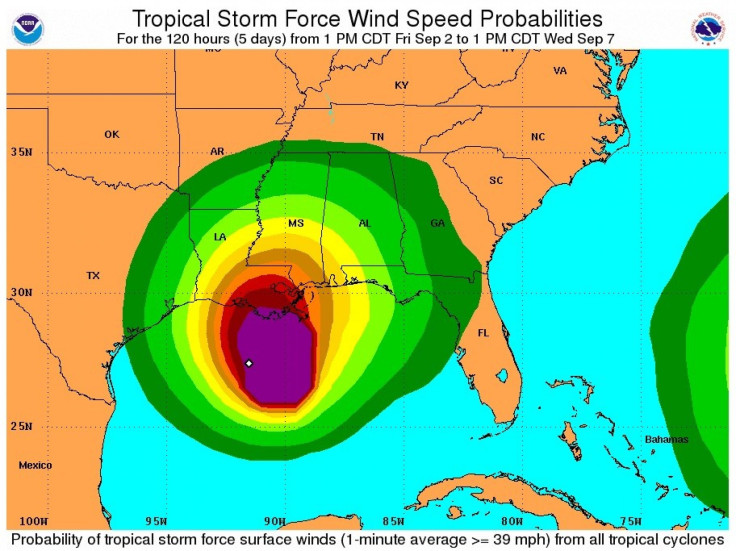
The National Hurricane Center issued another update on Friday stating that the storm was located about 170 miles southeast of Cameron, La., or 180 miles west southwest of the mouth of the Mississippi River, with winds of 45 miles per hour. Its present speed is 3 miles per hour.
Slow-moving systems like this bring flooding rainfall, which is said could be the primary threats from Lee at this time.
Besides flooding rain, there could be at least some coastal flooding, high surf and rip currents, which is a vastly underrated killer, according to The Weather Channel.
Weather officials expect rainfall of 10 to 15 inches on the coast from Alabama through Louisiana by Sunday evening. Some areas could get up to 20 inches of rainfall.
Two state governors and the mayor of New Orleans have already declared a state of emergency.
The Bureau of Ocean Energy Management, Regulation and Enforcement (BOEMRE) on Friday said personnel have been evacuated from a total of 169 production platforms, which is equivalent to 27 percent of the 617 manned platforms in the Gulf of Mexico.
Production platforms are structures located offshore from which oil and natural gas are produced. Unlike drilling rigs, which typically move from location to location, production facilities remain in the same location throughout a project's duration.
BOEMRE said operator reports showed that it is estimated that approximately 47.6 percent of the current oil production in the Gulf of Mexico has been shut down. It is also estimated that approximately 33 percent of the natural gas production in the Gulf of Mexico has seen similar fate. That's about 666,000 barrels of oil.
Strong winds and heavy rain have already began lashing down on Louisiana and Mississippi Gulf Coast residents on Friday afternoon as Lee lurches closer to New Orleans.
The bottom line is the longer it stays, the more rain we're going to get, Ken Graham of the National Weather Service forecasting office in Slidell, La., said in a conference call with reporters.
There have been drought conditions reported during the summer in the southern and the wet weather many come as a relief.
However, with so much water pouring down at once on the state, and with tides running two to five feet above normal, the water that will pile up in inlets, rivers and bays may have nowhere to drain, and could result in widespread inland flooding, forecasters said.
Bill Read, who serves as director of the National Hurricane Center, told The New York Times that there were additional concerns about flooding as the storm moves northeast into Appalachia. The intense rainfall over the rocky soil there could possibly lead to violent flash floods like those in New England and eastern New York after Hurricane Irene.
© Copyright IBTimes 2025. All rights reserved.
- MOST POPULAR IN Society