

NASA Pinpoints Fallen Satellite
After days of speculation, NASA officials announced Tuesday the location of the fallen Upper Atmosphere Research Satellite that crashed down to Earth.
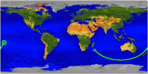
The Pacific Ocean - far away from landfall.
Officials at the Joint Space Operations Center at Vandenberg Air Force Base in California announced they had figured out the location at 14.1 degrees south latitude and 189.8 degrees east longitude (170.2 west longitude), they said in a statement. An accompanying map showed the location to be
This location is over a broad, remote ocean area in the Southern Hemisphere, far from any major land mass. The debris field is located between 300 miles and 800 miles downrange, or generally northeast of the re-entry point. NASA is not aware of any possible debris sightings from this geographic area.
NASA launched the 6.5 ton satellite in 1991 as part of an effort to measure and to better understand the Earth's atmosphere, including its ozone layer.
NASA's announcement Tuesday marked its final status report on the re-entry of the satellite that the organization decommissioned in 2005.
© Copyright IBTimes 2025. All rights reserved.
- MOST POPULAR IN Science


