

New Projections See Hurricane Sandy Strike The Mid-Atlantic Region

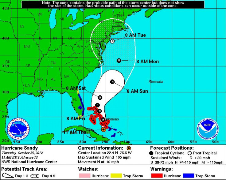
New projections for Hurricane Sandy's course released Thursday night are showing that instead of making a direct landfall near New York City, the storm may head farther south than predicted, ultimately striking in the mid-Atlantic region.
According to the Washington Post, the new storm-tracking models place Hurricane Sandy’s landfall in the vicinity of New Jersey and Delaware. Other models say the storm could hit as far south as Norfolk, Va. Previously, the models were predicting a New York City landing.
A mid-Atlantic hit could be disastrous for the region, leading to extensive flooding and damage to buildings from Washington, D.C., up to New Jersey. However, the Post notes that the storm could still shift from its projected path.
As Sandy approaches the Northeast, it is expected to merge with an eastern-moving snowstorm from the Midwest to create a “Frankenstorm” that is already being compared to 1991’s “Perfect Storm.”
According to a Thursday night advisory from the National Hurricane Center in Miami, the center of Hurricane Sandy was about 15 miles south-southwest of the Bahamas, approaching the island chain at 13 mph with maximum sustained winds decreasing to 90 mph. Hurricane force winds extended out 30 miles from the center, while tropical storm force winds extended outward up to 165 miles. Sandy is expected to remain a Category 2 storm throughout the week, though some weakening is expected in the next 48 hours as it moves north through the Bahamas.
Currently, a hurricane warning is in effect for the northwestern Bahamas, while tropical storm warnings and watches are in effect for various parts of Florida’s east coast.
© Copyright IBTimes 2025. All rights reserved.
- MOST POPULAR IN Science


