

Hurricane Katia Likely to Become Major Atlantic Storm; Projected Path Uncertain, U.S. Strike Possibility Remains
Hurricane Katia is likely to become a major storm this weekend, and an eventual threat to the U.S. has not been ruled out.
The National Hurricane Center said Thursday Katia, now about 1,000 miles east of St. Lucia in the Caribbean, is on a projected path to be well east of the Bahamas and south of Bermuda by Sept. 6. Katia has winds near 75 miles per hour, and the storm is moving west at 20 miles per hour.
Katia is the second hurricane of the 2011 Atlantic season, after Hurricane Irene, and though models are uncertain after early next week some examples do show the storm could make U.S. landfall. Also, another tropical system is developing in the Gulf of Mexico that could become a tropical depression in the next day or two, potentially impacting the U.S.
But as for Katia, the storm will be monitored closely over the next days as forecasters sharpen its likely projected path.
Strengthening is forecast during the next 48 hours, the NHC said. Katia could become a major hurricane by the weekend.
Katia is now a Category 1 storm on the five-step Saffir-Simpson scale. Major hurricanes, Category 3 on the scale, have winds greater than 110 mph -- and Katia is likely to reach that.
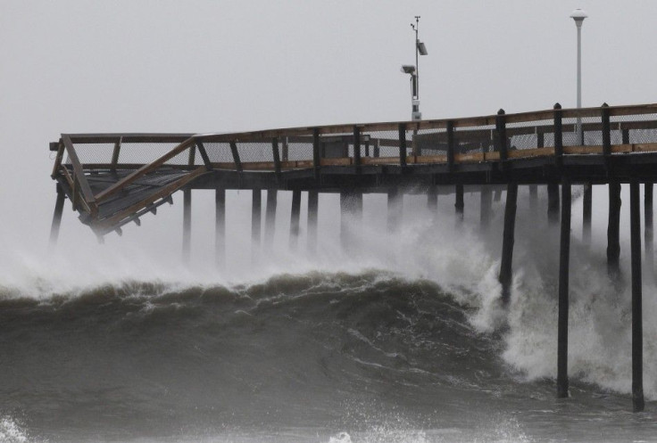
The big question, of course, in the wake of Hurricane Irene's U.S. East Coast destruction that millions are still dealing with from flooding and mass power outages, is whether or not Katia has decent odds striking America. Several computer models show Katia being push by a developing low pressure system away from the U.S. East Coast, while others show it could make landfall like Irene.
The other brewing potential threat to the U.S., as a system of thunderstorms over the southeastern Gulf of Mexico has a 60 percent chance of organizing into a tropical storm in the next two days, the NHC said.
Interests along the entire northern Gulf of Mexico coast should monitor the progress of this disturbance, the NHC said.
Energy companies with oil and gas interests in the Gulf of Mexico were keeping watch on the developing thunderstorms mass emerging in the northwest Caribbean Sea and eastern Gulf. BP Plc became the first major oil producer on Wednesday to say it was evacuating more than 500 non-essential workers from platforms in the Southern Green Canyon area.
London-based BP said it is preparing for a potential shut down in the Gulf region if necessary should the storm escalate.
Katia is the 11th named storm of the Atlantic hurricane season which runs from June 1 to Nov. 30. Irene became the first to reach hurricane strength, before ravaging a path up the East Coast last week.
Hurricane forecasters have been following Katia since Saturday when it emerged then-unnamed as a large area of showers and thunderstorms off the west coast of Africa. The storm became better organized on Sunday and Monday, when it became a tropical depression.
Katia's storm name replaces Katrina in the rotating storm roster because of the catastrophic damage from the 2005 storm which ravaged the U.S. Gulf Coast, causing catastrophic flooding in New Orleans and virtually destroying the Mississippi coastline.
© Copyright IBTimes 2025. All rights reserved.
- MOST READ


